
Pricing Change
New pricing for orders of material from this site will come into place shortly. Charges for supply of digital images, digitisation on demand, prints and licensing will be altered.
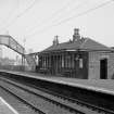
Bowling Station, Footbridge


Footbridge (Period Unassigned)
Site Name Bowling Station, Footbridge
Classification Footbridge (Period Unassigned)
Canmore ID 43396
Site Number NS47SW 67.01
NGR NS 44369 73696
Datum OSGB36 - NGR
Permalink http://canmore.org.uk/site/43396

- Council West Dunbartonshire
- Parish Old Kilpatrick (Dumbarton)
- Former Region Strathclyde
- Former District Dumbarton
- Former County Dunbartonshire

