
Following the launch of trove.scot in February 2025 we are now planning the retiral of some of our webservices. Canmore will be switched off on 24th June 2025. Information about the closure can be found on the HES website: Retiral of HES web services | Historic Environment Scotland
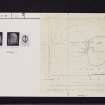
Langbank, River Clyde


Crannog (Period Unknown)(Possible)
Site Name Langbank, River Clyde
Classification Crannog (Period Unknown)(Possible)
Alternative Name(s) Baby Island; Langbank Crannog
Canmore ID 43344
Site Number NS47SW 22
NGR NS 4355 7283
Datum OSGB36 - NGR
Permalink http://canmore.org.uk/site/43344


- Council Renfrewshire
- Parish Erskine
- Former Region Strathclyde
- Former District Renfrew
- Former County Renfrewshire
NS47SW 22 4355 7283
Not to be confused with:
NS37SE 9 NS 3813 7355 Langbank West Crannog, or
NS47SW 29 NS 4050 7328 Langbank East Crannog
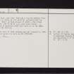
A crannog at Langbank was excavated by Bruce in 1901-2. It was first noticed by him when passing in the train, as a circle of stones, visible on the mud-flat when the tide receded. An islet, known as the Baby Island, had been on the site for a considerable period, though only a few tufts of grass remained on his first visit. It was situated about 50 yards from high water mark, in a line due north from the West lodge of Erskine House [Dove Cottage or Longhaugh Lodge: NS47SW 124].
Excavation showed that its construction was similar to that of the crannog at Dumbuck (NS47SW 8) with which it is probably contemporary. It consisted of a circle of wooden piles about 50 feet in diameter. Among the artifacts found were a semicircular bone comb bearing Iron Age decoration, and a small penannular bronze brooch, datable to the 2nd century AD. (A shale disc, now lost, bearing a cup and gapped ring, from here is noted as "of doubtful authenticity" by Morris. Other incised pieces of shale, like those at Dumbuck - NS47SW 8, were also found). A collection of material from this site is in the National Museum of Antiquities of Scotland (NMAS, Accession nos: HC 108-13).
J Bruce 1908; J G Callander 1929; C M Piggott 1955; J G Scott 1966; R W B Morris 1969; NMAS MS accessions list.
Though the site of this crannog was not located in 1964, J Hunter (Keeper of Archaeology, Paisley Museum and Art Galleries) gives its site as NS 4355 7283 in a letter of 3 November 1972.
Visited by OS (WDJ), 25 May 1964.
The cited location remains unverified, but the crannog is evidently situated close inshore, within the intertidal zone and behind (to the S of) the line of the Southern river training wall.
Information from RCAHMS (RJCM), 22 March 2011.
Field Visit (27 May 2015)
On the date of visit no evidence of this alleged crannog was found at or in the vicinity of the previously reported location which consists of mudflat and salt marsh on thje south bank of the River Clyde. It appears that this site has been conflated with Langbank East crannog (Canmore ID 43351); accordingly, all the archive material associated with this record has been re-assigned to that for the Langbank East site.
Visited by RCAHMS (AGCH, DD) 27 May 2015.

