
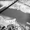
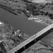
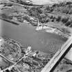
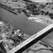
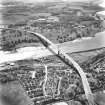
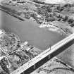
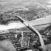
Erskine Bridge


Jetty (18th Century)
Site Name Erskine Bridge
Classification Jetty (18th Century)
Alternative Name(s) River Clyde
Canmore ID 43314
Site Number NS47SE 57
NGR NS 46181 72284
Datum OSGB36 - NGR
Permalink http://canmore.org.uk/site/43314


- Council Renfrewshire
- Parish Erskine
- Former Region Strathclyde
- Former District Renfrew
- Former County Renfrewshire
Field Visit (27 May 2015)
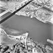
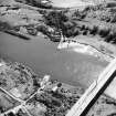
The remains of this jetty, which now extends just 17m into the River Clyde from its SW bank, are situated 100m SE of the Erskine Bridge (NS47SE 70). It measures 3.6m in breadth and comprises a rubble core within facing blocks and there is a narrow, slab-topped culvert running along its centre. The 1st edition of the OS 6-inch map (Renfrewshire 1863, sheet IV) depicts ‘South Jetty’ extending at least a further 75m NE to a beacon of which there are now no visible remains (see NS47SE 359). Towards its SW end the jetty crosses a natural exposure of stone that has previously been misidentified as a crannog.
Visited by RCAHMS (AGCH, DD) 27 May 2015.

