|
Photographs and Off-line Digital Images |
B 34001 CN |
|
Mappa Britanniae Faciei Romanae. Plate II from "Military Antiquities of the Romans in Britain" |
1793 |
Item Level |
|
|
Photographs and Off-line Digital Images |
B 34002 CN |
|
Albion et Hibernia. Plate III from "Military Antiquities of the Romans in Britain" |
1793 |
Item Level |
|
|
Photographs and Off-line Digital Images |
B 34033 CN |
Copies from a collection of drawings assembled by the Society of Antiquaries of London, London, Engl |
Plan showing the course of the Roman wall called Grime's Dyke (Antonine Wall). Plate XXXV from 'Military Antiquities of the Romans in Britain'. |
1793 |
Item Level |
|
|
Photographs and Off-line Digital Images |
B 34033 CS |
Copies from a collection of drawings assembled by the Society of Antiquaries of London, London, Engl |
Plan showing the course of the Roman wall called Grime's Dyke (Antonine Wall). Plate XXXV from 'Military Antiquities of the Romans in Britain'. |
1793 |
Item Level |
|
|
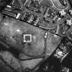
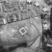
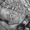
Photographs and Off-line Digital Images |
DB 923 |
RCAHMS Aerial Photography |
Oblique aerial view. |
1978 |
Item Level |
|
|
Photographs and Off-line Digital Images |
DB 924 |
RCAHMS Aerial Photography |
Oblique aerial view. |
1978 |
Item Level |
|
 |
On-line Digital Images |
SC 354130 |
RCAHMS Aerial Photography |
Oblique aerial view. |
1978 |
Item Level |
|
|
Photographs and Off-line Digital Images |
SC 904991 |
|
Plate XXXV from 'Military Antiquities of the Romans in Britain' showing course of Grimm's Dyke. (Antonine Wall) |
1793 |
Item Level |
|
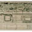 |
On-line Digital Images |
SC 934405 |
|
Drawing showing the course of the entire Antonine Wall along with plans and sections of the main forts and fortlets along the Wall. Surveyed in 1755.
Titled 'Plan showing the course of the Roman wall called grime's Dyke...together with plans of those stations belonging to the wall'.
|
1793 |
Item Level |
|
|
Photographs and Off-line Digital Images |
DP 006806 |
|
Digital image of plan of the Roman Fort and Annex at Golden Hill, Duntocher showing layout of internal structures. |
|
Item Level |
|
|
Photographs and Off-line Digital Images |
DC 47351/20 |
Records of the Ordnance Survey, Southampton, Hampshire, England |
Ordnance Survey 6-inch to the mile Provisional Edition , Revision of 1911 and 1914 with additions in 1938.
Additional annotations by Ordnance Survey for the Antonine Wall map covering the parish of Old Kilpatrick. |
c. 1938 |
Item Level |
|
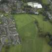 |
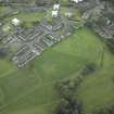
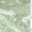
On-line Digital Images |
DP 018851 |
RCAHMS Aerial Photography Digital |
Oblique aerial view centred on the site of the Roman fort and Roman fortlet with the church adjacent, taken from the E. |
10/11/2006 |
Item Level |
|
 |
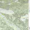
On-line Digital Images |
DP 020949 |
RCAHMS Aerial Photography Digital |
Oblique aerial view centred on the site of the Roman fort and Roman fortlet with the church adjacent, taken from the SE. |
8/9/2006 |
Item Level |
|
 |
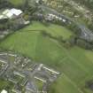
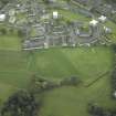
On-line Digital Images |
DP 020950 |
RCAHMS Aerial Photography Digital |
North oblique aerial view of Duntocher Roman Fort and Fortlet. |
8/9/2006 |
Item Level |
|
 |
On-line Digital Images |
DP 020951 |
RCAHMS Aerial Photography Digital |
NNW oblique aerial view of Duntocher Roman Fort and Fortlet with adjacent Trinity Parish Church. |
8/9/2006 |
Item Level |
|
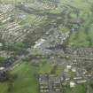 |
On-line Digital Images |
DP 020952 |
RCAHMS Aerial Photography Digital |
General oblique aerial view centred on the site of the Roman fort and Roman fortlet, taken from the WSW. |
8/9/2006 |
Item Level |
|
|
Digital Files (Non-image) |
GV 004329 |
Records of Historic Scotland, Edinburgh, Scotland |
A4 map of central Scotland showing the Antonine Wall, Council areas, World Heritage Site and buffer zones |
30/7/2007 |
Item Level |
|
 |
On-line Digital Images |
DP 249628 |
Historic Environment Scotland |
Oblique aerial view. |
24/3/2017 |
Item Level |
|
 |
On-line Digital Images |
SC 1724702 |
RCAHMS Aerial Photography |
Oblique aerial view. |
1978 |
Item Level |
|
 |
On-line Digital Images |
SC 1724703 |
RCAHMS Aerial Photography |
Oblique aerial view. |
1978 |
Item Level |
|
|
Digital Files (Non-image) |
GV 007524 |
Records of Historic Scotland, Edinburgh, Scotland |
Map 8 of 8 from IV.I 1-8 - Series 1: Maps of the Antonine Wall at a scale of 1:25000 showing the proposed World Heritage Site, known forts and fortlets, camps, other features and the buffer zones. Maps were prepared for the nomination document to propose the extension of the Frontiers of the Roman Empire World Heritage Site through the addition of the Antonine Wall. |
2006 |
Item Level |
|
 |
On-line Digital Images |
SC 1926675 |
Records of Historic Scotland, Edinburgh, Scotland |
Map 8 of 8 from IV.I 1-8 - Series 1: Maps of the Antonine Wall at a scale of 1:25000 showing the proposed World Heritage Site, known forts and fortlets, camps, other features and the buffer zones. Maps were prepared for the nomination document to propose the extension of the Frontiers of the Roman Empire World Heritage Site through the addition of the Antonine Wall. |
2006 |
Item Level |
|
|
Digital Files (Non-image) |
GV 007531 |
Records of Historic Scotland, Edinburgh, Scotland |
Map 8 of 8 from IV.2 1-8 - Series 2: Maps of the Antonine Wall at a scale of 1:25000 showing the proposed World Heritage Site, known forts and fortlets, camps, other features and the buffer zones. Maps were prepared for the nomination document to propose the extension of the Frontiers of the Roman Empire World Heritage Site through the addition of the Antonine Wall. |
2006 |
Item Level |
|
 |
On-line Digital Images |
SC 1927925 |
Records of Historic Scotland, Edinburgh, Scotland |
Map 8 of 8 from IV.2 1-8 - Series 2: Maps of the Antonine Wall at a scale of 1:25000 showing the proposed World Heritage Site, known forts and fortlets, camps, other features and the buffer zones. Maps were prepared for the nomination document to propose the extension of the Frontiers of the Roman Empire World Heritage Site through the addition of the Antonine Wall. |
2006 |
Item Level |
|


