
Lewis, Stornoway, General


Burgh (Medieval), Town (15th Century)
Site Name Lewis, Stornoway, General
Classification Burgh (Medieval), Town (15th Century)
Canmore ID 4326
Site Number NB43SW 24
NGR NB 42490 32831
NGR Description Centred NB 42490 32831
Datum OSGB36 - NGR
Permalink http://canmore.org.uk/site/4326


- Council Western Isles
- Parish Stornoway
- Former Region Western Isles Islands Area
- Former District Western Isles
- Former County Ross And Cromarty
STORNOWAY
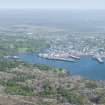
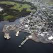
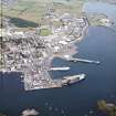
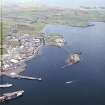
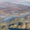
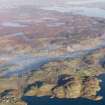
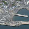
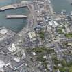
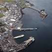
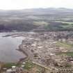
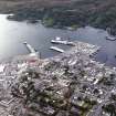
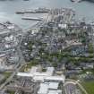
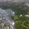
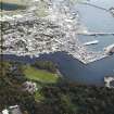
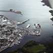
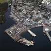
(Steornabhagh; Norse: Stiornu Vagr - anchor bay) The appearance of the capital of the Western Isles today owes much to the vast wealth of its 19th and early 20th century proprietors. They transformed the lively little mercantile town that had grown up in the old parish of Eye (Aoidhe/Uidh) into a relatively prosperous fishing port. Inevitably, perhaps, Stornoway's subsequent development as a modern ferry port has done little to enhance its historic fabric; the deadening hand of mediocre suburban sprawl is today all too evident. Stornoway's status as a royal burgh from 1628 had its origins in an Act of Parliament of 1597, by which James VI sought to maintain order among his feuding Gaelic subjects. As a result of non-compliance with his decree that all who claimed land in the Highlands and Islands produce their deeds, the Macleod lands in Lewis were declared forfeit. Their titles passed to the Crown, and were handed on to a group of 12 merchants known as the Fife Adventurers, who were contracted to 'plant policy and civilisation' and to colonise the 'hitherto most barbarous Isle of Lewis' with English-speaking lowlanders. These men set out with some 500 soldiers and craftsmen in 1598 and established 'a prettie town' on a small promontory with a sheltered anchorage that had probably been settled in Norse times. But they failed to promote allegiance to the monarch, or to pacify the marauding rival clans. In 1610, after three attempts, they sold Lewis to the Mackenzies who, by 1613 , had expropriated their Macleod rivals once and for all and captured Stornoway Castle. In 1653, Cromwellian troops constructed a fort on Goat Island and a fortress or citadel in what is now the Point Street area, to 'awe the neighbourhood'. A year later, in a fierce battle with the islanders, they destroyed the old Macleod stronghold of Stornoway Castle. (Surviving vestiges were obliterated in 1882, with the construction of D. & T. Stevenson's steamer wharf on South Beach, later extended as King Edward VII Wharf). Martin Martin noted in 1695 that the town which had begun to develop on a small peninsula between the inner and outer harbour known as the Point 'consists of about sixty families; there are some houses of entertainment in it, as also a church [St. Lennan] and a school, in which Latin and English are taught'. The main axis was Point Street, where the houses originally looked inwards with their backs to the water. It is likely that much of the domestic architecture resembled that of the Low Countries, since many Dutchmen were granted fishing rights and settled here in the 17th century. By 1773, Kenneth Street had opened up as a new thoroughfare, Cromwell Street was well established and a pier was under construction. Twenty years later, J. L. Buchanan portrayed the by now well-established fishing port of Stornoway, as a cosmopolitan place 'with equal commodiousness and elegance laid out in regular buildings and streets. The merchants have built excellent piers and quays … public houses and coffee rooms … [their houses] plentifully supplied, by means of their home and foreign markets, with all the necessaries, and even luxuries of life'. According to the OSA, the town by 1797 had 67 inhabited slated houses of the best materials, a customs house, town house, assembly room, two schoolhouses, and more than 20 thatched houses fronting the bay on the north-west side of town. Close to these was a huddle of numerous thatched huts of a more miserable quality, occupied by sailors and fishermen. The geometrical plan of Georgian Stornoway is shown clearly in John Wood's survey of 1821 . This also reveals the grand proposal for a development of streets radiating out from the church, very much in the spirit of Macdonald of Sleat's plans for Kyleakin and Portree and, like them, unfulfilled. When, in the later 19th century, Stornoway did extend eastwards, it was in grid formation. By the mid-19th century there were three mills (one for carding wool), a distillery, five schools, 'respectable looking shops…, 18 pubs - '… no want of inns and other places of refreshment' - and a bank. Sir James Matheson also provided drinking fountains and, in 1849, a gasworks which lit the streets. From the turn of the 19th century to the 1920s survives some housing of hitherto unrecognised interest - a group of buildings that displays an impressive provincial confidence in its richly inventive use of concrete and cement for dressings and flamboyant architectural details. Lord Leverhulme's vision for a model town, as illustrated by J. Raffles Davison in his bird's eye view of 1920, Venice of the North, was refined and developed by Thomas Mawson and J. Lomax-Simpson. But the failure of his dream for the once cosmopolitan burgh, whose population had more than doubled during the late 19th century herring boom, coincided with depression and stagnation on the island.
Taken from "Western Seaboard: An Illustrated Architectural Guide", by Mary Miers, 2008. Published by the Rutland Press http://www.rias.org.uk

Publication Account (1985)
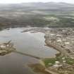
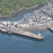
Stornoway is the principal town in the Western Isles and one of the largest in Argyll and the Isles. A sheltered anchorage on the east coast of Lewis, the site has obviously been of importance for many centuries, though nearly all the buildings to be seen now are of 19th century date or later.
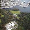
The medieval castle, destroyed by Cromwell's troops in 1654, was the stronghold of the MacLeods who were chiefs in Lewis from the 13th century, but during the 16th century the island passed into the hands of MacKenzie of Kintail and eventually was sold to James Matheson in 1844. The town was already spreading from its early site between North and South Beach and Kenneth Street; Matheson built new houses, improved roads, gas and water supplies, and constructed new quays, which encouraged development of the fishing industry and led to the growth and prosperity of the town. He also built Lews Castle and planted the grounds with a variety of trees and shrubs; the Castle grounds, now open to the public, contain one of the largest areas of deciduous woodland in the Western Isles, and provide a peaceful contrast to the bustle of the town. The Castle is now a College of Further Education.
There are no buildings of outstanding architectural interest, but a number have unusual details and the observant visitor may see a variety of building styles and functions in a stroll through the commercial streets and the quieter parts of town. There are pleasant 19th century frontages on South Beach and above the shops on Cromwell Street, including stone facades and ornate gables. Amity House, the offices of the Pier and Harbour Commission, is a handsome building and nearby on North Beach is a building with loft doors and small round windows under the eaves; this was probably used at one time for drying and storing nets. The former Town Hall on South Beach was built in 1905 in the Scots Baronial style, to designs by John Robertson ofInverness, and is now the location of the new museum, Museum nan Eilean, Steornabhagh, which illustrates the geology and history of the area.
A little further from the centre there is the Nicholson Institute, the only senior secondary school in the Western Isles. In Matheson Road there are several houses built by Lord Leverhulme when he was proprietor of the island, and, beyond a vigorous suburban growth, the hospital and an industrial estate, including mills where wool for the Harris tweed is dyed and spun and the completed tweeds are washed and checked.
Information from ‘Exploring Scotland’s Heritage: Argyll and the Western Isles’, (1985).

