
Following the launch of trove.scot in February 2025 we are now planning the retiral of some of our webservices. Canmore will be switched off on 24th June 2025. Information about the closure can be found on the HES website: Retiral of HES web services | Historic Environment Scotland
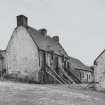
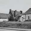
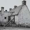
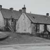
Paisley, Elderslie, 243 Main Road, 'wallace's House'


Lairds House (Medieval)(Possible), Moated Site (Medieval)
Site Name Paisley, Elderslie, 243 Main Road, 'wallace's House'
Classification Lairds House (Medieval)(Possible), Moated Site (Medieval)
Alternative Name(s) The Wallace Buildings; Wallace Memorial
Canmore ID 43228
Site Number NS46SW 4
NGR NS 44219 63048
Datum OSGB36 - NGR
Permalink http://canmore.org.uk/site/43228


- Council Renfrewshire
- Parish Paisley (Renfrew)
- Former Region Strathclyde
- Former District Renfrew
- Former County Renfrewshire
NS46SW 4 44219 63048
(NS 4421 6304) Wallace's House (NR)
OS 6" map (1857)
The New Statistical Account (NSA) states that though this rather old-looking tenement, near the west end of Elderslie, is pointed out as the birthplace of Sir William Wallace (in 1270), if he was born here, it must have been in an earlier building on the same site. An old garden adjoins this house, a stone incribed "W W W Christ is only my Redeemer" in Roman letters was dug from the foundation of its walls early in the 19th century. It was taken to Elderslie House, the seat of Alexander Speirs (NSA 1845).
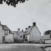
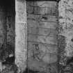
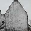
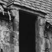
This house, probably known as "Wallace's House" is in a good state of preservation.
Name Book 1857
The building is now used as a storehouse and coalhouse. The tradition that it was Wallace's house still survives locally.
Visited by OS (JHO) 28 February 1951
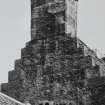
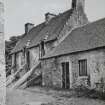
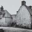
The present building that bear Wallace's name are said to mark the site of his abode (cf NS46SW 18). The Account goes on to state that this is known also as 'Moat House' having strong corner bastions and walls connecting them in the garden, and protected by a moat 16 to 20ft wide.
Third Statistical Account (TSA) 1962
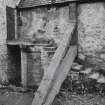
Mrs Hallifax Crawford says that the medieval kitchen, in a disused building, still retains the barrel-vaulted roof, fireplace and oven. This building also contains a number of sculptured stones taken from the castle.
A Hallifax-Crawford 1965
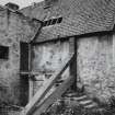
This group of buildings has been demolished except for one part of an outhouse to the medieval building.
Visited by RCAHMS (JBS) 18 April 1985
NMRS REFERENCE:
George Stewart Sketches - 1 pencil drawing c.1866.
Photographic Survey (July 1963)
Photographs by the Scottish National Buildings Record in July 1963.
Field Visit (1996 - 2003)
Russell Coleman managed an Historic Scotland funded project to record medieval moated sites in Scotland. Gazetteers were produced for each regional council area between 1996 and 2002 with an uncompleted overall review in 2002-03. The results of the first year of the project were published in Tayside and Fife Archaeological Journal, Volume 3 (1997).
Excavation (1998)
NS 442 630 An archaeological evaluation was undertaken in the area around the Wallace Memorial, reputedly the birthplace of Sir William Wallace. The fieldwork was carried out prior to the re-landscaping of the site. It was hoped that the results would be able to throw some light on the settlement history of the site which could be taken into account during the landscaping or used for public presentation.
A total of seven trial trenches were excavated, two in the garden of Moat House, to the S of the memorial, and five in the area around the memorial itself. Early map evidence suggested that there was a large rectilinear moated enclosure on the site with a number of rounded corner towers, only one of which now survives in the eastern corner of the garden. Excavation across this moat revealed it to be at least 4.5m wide, 1.3m deep, and flat-bottomed, with its inner edge faced by a battered and mortared rubble wall. The exact date of this feature remains unclear but, on balance, a 13th-14th century date is favoured on the basis of pottery finds and comparable examples elsewhere.
The extrapolated line of this moat was also investigated along the NW side and N corner of the enclosure. At the latter there were no traces of a rounded tower similar to that at the E corner, but the remains of a possible ditch were located. Along the NW side, adjacent to the foundations of what is usually termed 'Wallace's House', the inside edge of what may be a rock-cut ditch was also located. In addition, this area produced a large number of post-medieval, green-glazed pottery sherds, probably dating to the 16th-17th century. Apart from these finds the numbers of artefacts recovered from the interior of the enclosure was limited and much of the ground appears to have been disturbed by previous building and demolition work. However, a number of negative features, including post-holes and pits of unknown date, were discovered cut into the natural subsoil.
A report will be lodged with the NMRS and West of Scotland Archaeology Service SMR.
Sponsors: Renfrewshire Council, Renfrewshire Enterprise.
Information from D Alexander - CFA Archaeology Ltd.
Source: DES, Volume, 1998
Change Of Classification (18 September 2024)
Previously recorded as a tenement but has now been classified as a House. The description of the Wallace's House in the NSA (1845) as a tenement, is misleading as the use of the term changed in the mid to late 19th century.
Moated site has been added to the record.
The Commemorative Monument has been removed as there is an existing site for the memorial (see NS46SW 243).
Information from HES 18 September 2024.

