
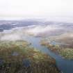
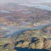
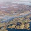
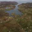
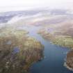
Lewis, Ranish


Head Dyke (Post Medieval), Township (Period Unassigned)
Site Name Lewis, Ranish
Classification Head Dyke (Post Medieval), Township (Period Unassigned)
Alternative Name(s) Ranais, Raerinish
Canmore ID 4293
Site Number NB42SW 3
NGR NB 4050 2480
NGR Description Centred on NB 4050 2480
Datum OSGB36 - NGR
Permalink http://canmore.org.uk/site/4293


- Council Western Isles
- Parish Lochs
- Former Region Western Isles Islands Area
- Former District Western Isles
- Former County Ross And Cromarty
Note
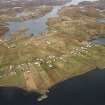
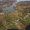
A township comprising sixty roofed buildings, one partially roofed building, eleven unroofed buildings, several of which are annotated as Ruins, several enclosures and a head-dyke is depicted on the 1st edition of the OS 6-inch map (Ross-shire, Island of Lewis 1854, sheet 33). Eighty-nine roofed, five partially roofed and forty-one unroofed buildings are shown on the current edition of the OS 1:10000 map (1973).
Information from RCAHMS (SAH) 25 July 1997

