
Lewis, Loch Cromore, Dun Cromore


Broch (Iron Age)(Possible), Causeway (Iron Age), Galleried Dun (Iron Age)
Site Name Lewis, Loch Cromore, Dun Cromore
Classification Broch (Iron Age)(Possible), Causeway (Iron Age), Galleried Dun (Iron Age)
Canmore ID 4292
Site Number NB42SW 2
NGR NB 40123 20699
Datum OSGB36 - NGR
Permalink http://canmore.org.uk/site/4292


- Council Western Isles
- Parish Lochs
- Former Region Western Isles Islands Area
- Former District Western Isles
- Former County Ross And Cromarty
NB42SW 2 40123 20699
(NB 401 206) Dun Cromore (NR)
OS 6"map, Ross-shire, 2nd ed., (1899)
Dun Ban, Cromore - plan and elevations.
F W L Thomas 1890.
Dun Cromore.
RCAHMS 1928, visited 1921.
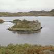
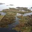
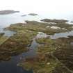
Dun Cromore is an oval galleried dun, situated 50 yards from the west side of Loch Cromore.
The interior measures 52ft by 44ft within a wall containing cells and a gallery, the latter reported to have had a stair within it which led up to a third gallery, passing by a second. All these upper works have now been destroyed. An arc of walling forms a courtyard outside the entrance, to the NW.
R W Feachem 1963.
Dun Cromore, at NB 4011 2068, is as described by Feachem and planned by the RCAHMS. There is a submerged causeway from the dun to the west shore of the loch.
Visited by OS (N K B) 23 June 1969.
Field Visit (2 July 1921)
Dun Cromore, Loch Cromore, Loch Erisort.
On an islet about 50 yards from the end of a promontory on the west side of Loch Cromore, and springing direct from the water's edge, is the ruin of Dun Cromore, sometimes called Dun Ban; a broch occupying the south-eastern part, with the remainder to the north-west forming an outer ward enclosed with a low broken wall about 4 feet 6 inches thick and 28 feet at most distant from the broch. (Figs. 31, 32.)
The broch is oval on plan with axes 52 feet and 44 ½ feet; the walls, varying from 7 feet to10 feet 9 inches in thickness, attain a height of from 10 to 12 feet. It has been connected to the mainland from the ward by a causeway still visible under water. The break in the wall at the north-west has presumably been the entrance, from the south jamb of which along narrow cell 12 feet by 3 feet has opened, and a somewhat similar one is traceable on the north. In the southern arc of the wall is a gallery, averaging 2 feet in width, now unceiled, with no entrance discernible. Captain Thomas in his description* mentions that within the gallery at the time of his visit a stair of seventeen steps led up to a third gallery, and underneath them a smaller stair led down from a second but with no exit. Though the gallery walls still remain as shown on his plan there is now nothing to suggest that stairs ever existed here.
A straight jamb of a void penetrates the wall on the north of the court, but its purpose is uncertain.
The foundations of later buildings were noticed under a tangle of briar or dog roses which overgrows the interior.
RCAHMS 1928, visited 2 July 1921.
OS Map: Lewis xxxiii.
*Archaeal. Scot., v., p. 380.
Publication Account (2007)
NB42 1 DUN CROMORE ('Dun Ban')
NB/401206
This probably ground-galleried broch in Lochs, Lewis, stands on an islet scarcely bigger than itself in Loch Cromore; the islet is about 50m from the end of a promontory to the west (visited August 1971 and August 1985). There is a submerged causeway to this promontory [1,2] but it was not seen by the writer in 1985, nor encountered when he then rowed a boat all round the islet.
1. Early descriptions
Colin Mackenzie visited the site in about 1780 but his description is very brief; the wall is described as about 10 feet in height [2]. The accompanying cross-section is entirely fanciful and is not really explained.
Captain F W L Thomas surveyed the site in about 1860 and many of the features he described then are no longer visible; his account is therefore a valuable historical source [3]. The paragraphs are lettered here as usual.
(A) "This Dun was a very great puzzle, and I left it at the first time with quite a false impression, for it was believed to be an entirely new style of fortification; but subsequent exploration proved that the door of the dun had been built up, that one half of the enceinte had been re-built, and that two or more characteristic Lewis cottages had been partly excavated, partly built, of the stones that filled the area.
(B) The dun is on a rocky islet, which is joined to the shore by a sunk causeway, about 80 feet long, on which was a row of stepping stones, in a curved line, some of which remain. The islet is 60 feet long and 40 feet broad, and is low and flat.
(C) The Dun (Pl. XLIX) is not truly circular, the longest diameter being 50 feet and the shortest 44 feet. The average thickness of the old wall is 7 1/2 feet, and of the secondary wall about the same; but, as there is no proper inner facing to that part, its thickness could not be measured. The highest part now left of the wall is 111/2 feet or 14 feet above the water.
(D) On landing there is 31 feet of glacis, or rather of rocks and brambles, to the door, which fronts the causeway. We found the doorway built up, but cleared it out entirely. The doorway is 3 1/2 feet wide at first, continues so for 3 feet, then widens to 5 feet.
(E) On the south side of the doorway (a) is the door of the guard cell (b), 1 1/2 feet wide, and the cell continues as a ground gallery (c) for 16 feet, when it is blocked (d). The roof of the ground gallery forms the floor of the second gallery, from which a flight of steps leads down to the ground into another cellar-like place (e), and this again is blocked by the stairs of the third gallery (f). This part of the construction is very singular. From the ground area of the dun a doorway (g) 3 feet wide and 7 feet high, is pierced through the inner wall, entering on a landing, from which a flight of seventeen steps (h) leads to a third gallery; and this is all that now remains. The place is very ruinous, and it was with difficulty that so much of the plan of construction could be made out.
(F) On the north side of the door a half moon is hollowed out of the thickness of the wall, but I could not understand its purpose. Here the original masonry ends and a thick, rude, solid wall, built no doubt on the original foundations, completes the enceinte as far as the "grand" staircase.
(G) The area of the dun is partly occupied by two oblong cottages …"
2. Description
The Commission saw the causeway under the water in 1921 but the author could see nothing in 1985; presumably the water level was then temporarily higher.
The broch itself occupies the south-east part of the islet and the north-west part is a small outer court enclosed by a wall 1.37m (4.5 ft) thick. This joins the broch wall at the west end, runs out to a maximum distance of 8.54m (28 ft) from it and down to the water's edge on the north-west [4, fig. 38]. Presumably there was an outer doorway in this wall leading directly on to the causeway but nothing can now be seen. Viewed from the north-west it can be seen that the outer face of the broch wall here has fallen and the rubble is covered by vegetation; else-where the outer face is well preserved.
Thomas clearly implies that from the north round to the south-west the main wall is a secondary construction, built solid; if so Dun Cromore might be compared to Dun Baravat (NB13 1), where the high broch wall only exists in the part facing the causeway. However the Commission traced an upper intra-mural gallery in a large part of that supposedly solid wall (from south-west to south-east) and there seems no real reason to doubt that the broch double wall continues all the way round. There are signs of extensive rebuilding on the north-east side but this is doubtless connected with the insertion of the medieval rectangular dwellings into the rubble-filled court (as at Dun Ringill: NG51 4). The entrance passage had been blocked with later masonry but Capt. Thomas cleared this in 1860. This is doubtless why the entrance is now so ruinous.
The structure is oval in plan with axes of 15.86m (52 ft) from north-west to south-east and 13.57m (44.5 ft) from north-east to south-west (the NMRS site entry wrongly states that these are the internal measurements [1]). The outer face of the wall still stood about 3.66m (12 ft) high on the east and south in 1921 [4] and is not much less than that now. It was the same height – or 4.27m (14 ft) above the water – in the 19th century [3]. The wall thicknesses given – from 2.12m (7 ft) to 3.28m (10 ft 9 in) [4] – are across the wallhead and would doubtless be greater at the base. Feachem classifies the site as a galleried dun rather than a broch but his reasons for making the distinction are not clear [5].
The Commission saw a break in the wall on the north-west which must be the entrance passage described by Thomas.
It is very difficult to see any structural features now, and even by 1921 a certain amount of dilapidation had evidently occurred since Thomas' visit [4]. In 1985 a local man told the author that a mass of stone had been removed from the island some decades earlier to build some cottages near the loch.
3. Structural analysis
Level 1: it is evident that Thomas' belief that much of the broch wall – from north-east clockwise to the south-west – was a later construction of cruder, solid masonry is mistaken. An upper gallery of standard hollow-wall type was later seen running along a large part of this stretch (below) [4, fig. 38] (Illus. 9.049). It can be assumed that an intra-mural gallery also ran round most of the wall in Level 1 but evidence is scanty.
The doorway, facing north-west and along the causeway, was described by Thomas who evidently saw the door-frame 92cm (3 ft) in from the outer end (para. D, above). There were evidently two opposed and elongated guard cells opening from the passage sides and he saw the doorway to the one on the right (south), only 46cm (18 in) wide (para. E above). He interpreted this cell as a ground gallery, blocked after 4.88m (16 ft) , but the Commission saw there the rounded end of a cell 3.66m (12 ft) long [4].
Thomas also describes here the same strange feature which he thought he saw at Dun Baravat (NB13 1), namely a short stairway leading down from the Level 2 gallery above the guard cell into a “cellar” with no exit (Illus. 9.056, longitudinal section). Thus the end of the ground gallery he saw was evidently not blocked by fallen rubble but by the back of this flight of stairs. At Dun Baravat, as we have seen, this feature almost certainly did not exist, the stair concerned being the main one rising to the right of the stair door. It seems likely that at this site Thomas mistook the curved end of the right guard cell for the back of a short stair, perhaps being influenced by his observations at Dun Baravat. A stair going down into an otherwise inaccessible space in Level 1 has never been found in any other broch or broch-like structure.
By contrast there is no reason to doubt that the other stair he saw is real; it rose in a flight of 17 steps to the right of a stair door g at about 2.30 o'clock which is said to be 2.14m (7 ft) high. The flight rose to meet a small fragment of the lintel flooring of a third gallery. In this case Thomas' elevation along the wall does not agree with his description. The drawing shows the stair running straight up from ground level (this must have been a guess since the site is unexcavated) to a landing in Level 1I, and shows the stair door as if running up into Level 1. The latter has almost certainly lost its lintel so that door and void above it are combined in the drawing.
However the description (para. E above) says that the stair door enters on a landing and something like this is shown in the cross-section xy . If the site was as encumbered with rubble then as it is now it is hard to see how any ground level feature could be inferred with confidence. The longitudinal elevation is taken to be the most plausible interpretation here.
Any scarcement on the inner wallface must still be buried under rubble. How the intra-mural stair could have reached this through a void in Level 1 is entirely obscure at present; the stair is recorded as rising up to Level 1I without a suitable landing in it, but again this may be an inference.
Level 2: it was clear at the time of Thomas' visit that the lintels over the ground level gallery (or long cell) on the west side formed the floor of a first floor gallery [3] and as noted he also thought he saw a few steps leading anti-clockwise downwards from this level into a “cellar-like place” immediately behind the main stairway (below). This is assumed here to be a mistake. The Commission saw further traces of the first floor gallery all round the southern arc [4] and the outer half of the double wall is still standing 1.4m high on the south, and slightly less on the south-west. The straight side of a void, presumably at first floor level, was seen in the inner wallface on the north side [4]. The north-east arc of the wall is shown solid on the 1921 plan [4] but this is doubtless because traces of the upper gallery here are hidden by rubble.
Level 3: as noted Thomas recorded a few lintels of the second storey gallery on the west side, reached by the stair.
Secondary buildings: the foundations of two sub-rectangular buildings were traceable in the interior [3] and straight wallfaces are still visible among the vegetation. There are signs of extensive rebuilding of the broch wall on the north-west, where the entrance has been.
Dimensions
Internal diameters (presumably above the scarcement), north-west to south-east c. 10.37m (34 ft), north-east to south-west c. 8.69m (28.5 ft). The average wall proportion here is about 37.5% but since the internal diameter must be less below the scarcement, and since the outer face has a batter, the real wall proportion is probably nearer 40% or a little higher.
Sources: 1. NMRS site no. NB 42 SW 2: 2. Mackenzie 1789: 3. Thomas 1890, 380-82 and pl. XLIX: 4. RCAHMS 1928, 11-12, no. 38, and figs. 31, 32 and 38: 5. Feachem 1963, 182.
E W MacKie 2007

