 |
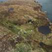
On-line Digital Images |
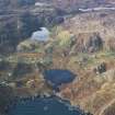
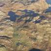
DP 110090 |
RCAHMS Aerial Photography Digital |
Oblique aerial view centred on Loch Dubh and Calbost township, taken from the E. |
14/11/2011 |
Item Level |
|
 |
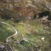
On-line Digital Images |
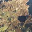
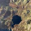
DP 111273 |
RCAHMS Aerial Photography Digital |
Oblique aerial view of the remains of the township, head dyke and lazy beds at Calbost, Loch Dubh, Lewis, taken from the SW. |
16/11/2011 |
Item Level |
|
 |
On-line Digital Images |
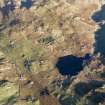
DP 111274 |
RCAHMS Aerial Photography Digital |
Oblique aerial view of the remains of the township, head dyke and lazy beds at Calbost, Loch Dubh, Lewis, taken from the SW. |
16/11/2011 |
Item Level |
|
 |
On-line Digital Images |
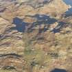
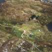
DP 111275 |
RCAHMS Aerial Photography Digital |
General oblique aerial view of the remains of the township, head dyke and lazy beds at Calbost, looking towards the township of Marvig, Lochs, Lewis, taken from the S. |
16/11/2011 |
Item Level |
|
 |
On-line Digital Images |
DP 111276 |
RCAHMS Aerial Photography Digital |
General oblique aerial view of the remains of the township, head dyke and lazy beds at Calbost, looking towards the township of Marvig, Lochs, Lewis, taken from the S. |
16/11/2011 |
Item Level |
|
 |
On-line Digital Images |
DP 111277 |
RCAHMS Aerial Photography Digital |
Oblique aerial view of the remains of the township, head dyke and lazy beds at Calbost, Loch Dubh, Lewis, taken from the NE. |
16/11/2011 |
Item Level |
|
 |
On-line Digital Images |
DP 111278 |
RCAHMS Aerial Photography Digital |
Oblique aerial view of the remains of the township, head dyke and lazy beds at Calbost, Loch Dubh, Lewis, taken from the NNE. |
16/11/2011 |
Item Level |
|
 |
On-line Digital Images |
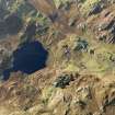
SC 1692427 |
RCAHMS Aerial Photography |
Oblique aerial view centred on the remains of the township, taken from the WSW. |
25/9/2004 |
Item Level |
|
 |
On-line Digital Images |
SC 1692428 |
RCAHMS Aerial Photography |
Oblique aerial view centred on the remains of the township, taken from the SW. |
25/9/2004 |
Item Level |
|
 |
On-line Digital Images |
SC 1692429 |
RCAHMS Aerial Photography |
Oblique aerial view centred on the remains of the township, taken from the SW. |
25/9/2004 |
Item Level |
|
 |
On-line Digital Images |
SC 2345546 |
Records of the Ordnance Survey, Southampton, Hampshire, England |
Lewis, Calbost, NB41NW 1, Ordnance Survey index card, Recto |
c. 1958 |
Item Level |
|


