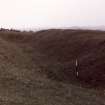
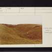
|
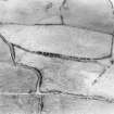
Photographs and Off-line Digital Images |
A 78953 CN |
Records of the Ordnance Survey, Southampton, Hampshire, England |
Barnwell earthwork, view of S ditch from E. |
1982 |
Item Level |
|
|
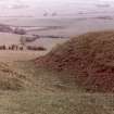
Photographs and Off-line Digital Images |
A 78954 CN |
Records of the Ordnance Survey, Southampton, Hampshire, England |
Barnwell earthwork, view of SW ditch from S. |
1982 |
Item Level |
|
|
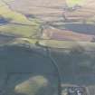
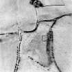
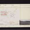
Photographs and Off-line Digital Images |
D 76079 |
RCAHMS Aerial Photography |
Oblique aerial view centred on the remains of the homestead moat, quarry and rig, taken from the SE. |
24/8/2000 |
Item Level |
|
|
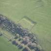
Photographs and Off-line Digital Images |
D 76080 |
RCAHMS Aerial Photography |
Oblique aerial view centred on the remains of the homestead moat, quarry and rig, taken from the NE. |
24/8/2000 |
Item Level |
|
|
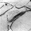
Photographs and Off-line Digital Images |
D 76081 |
RCAHMS Aerial Photography |
Oblique aerial view centred on the remains of the homestead moat, quarry and rig, taken from the N. |
24/8/2000 |
Item Level |
|
|
Photographs and Off-line Digital Images |
D 76082 |
RCAHMS Aerial Photography |
Oblique aerial view centred on the remains of the homestead moat, quarry and rig, taken from the NW. |
24/8/2000 |
Item Level |
|
 |
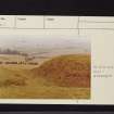
On-line Digital Images |
DP 147707 |
RCAHMS Aerial Photography Digital |
General oblique aerial view of the moated site and church at Barnweill, looking SE. |
30/11/2012 |
Item Level |
|
 |
Digital Files (Non-image) |
WP 000760 |
Records of the Royal Commission on the Ancient and Historical Monuments of Scotland (RCAHMS), Edinbu |
Scanned copy of RCAHMS Marginal Land Survey unpublished typescripts (Ayrshire), with index. |
1952 |
Item Level |
|
 |
On-line Digital Images |
DP 213288 |
RCAHMS Aerial Photography Digital |
Oblique aerial view of Barnweill moated site, looking ESE. |
21/4/2015 |
Item Level |
|
 |
On-line Digital Images |
SC 1724568 |
RCAHMS Aerial Photography |
Oblique aerial view centred on the remains of the homestead moat, quarry and rig, taken from the SE. |
24/8/2000 |
Item Level |
|
 |
On-line Digital Images |
SC 1724569 |
RCAHMS Aerial Photography |
Oblique aerial view centred on the remains of the homestead moat, quarry and rig, taken from the NE. |
24/8/2000 |
Item Level |
|
 |
On-line Digital Images |
SC 1724570 |
RCAHMS Aerial Photography |
Oblique aerial view centred on the remains of the homestead moat, quarry and rig, taken from the N. |
24/8/2000 |
Item Level |
|
 |
On-line Digital Images |
SC 1724571 |
RCAHMS Aerial Photography |
Oblique aerial view centred on the remains of the homestead moat, quarry and rig, taken from the NW. |
24/8/2000 |
Item Level |
|
 |
On-line Digital Images |
SC 2262122 |
Records of the Ordnance Survey, Southampton, Hampshire, England |
Barnwell earthwork, view of S ditch from E. |
1982 |
Item Level |
|
 |
On-line Digital Images |
SC 2262123 |
Records of the Ordnance Survey, Southampton, Hampshire, England |
Barnwell earthwork, view of SW ditch from S. |
1982 |
Item Level |
|
 |
On-line Digital Images |
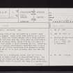
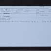
SC 2425272 |
Records of the Ordnance Survey, Southampton, Hampshire, England |
Barnweill, NS43SW 8, Ordnance Survey index card, page number 1, Recto |
1958 |
Item Level |
|
 |
On-line Digital Images |
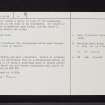
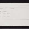
SC 2425273 |
Records of the Ordnance Survey, Southampton, Hampshire, England |
Barnweill, NS43SW 8, Ordnance Survey index card, page number 2, Verso |
1958 |
Item Level |
|
 |
On-line Digital Images |
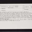
SC 2425274 |
Records of the Ordnance Survey, Southampton, Hampshire, England |
Barnweill, NS43SW 8, Ordnance Survey index card, Recto |
1958 |
Item Level |
|
 |
On-line Digital Images |
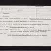
SC 2425275 |
Records of the Ordnance Survey, Southampton, Hampshire, England |
Barnweill, NS43SW 8, Ordnance Survey index card, Recto |
1958 |
Item Level |
|
 |
On-line Digital Images |
SC 2425276 |
Records of the Ordnance Survey, Southampton, Hampshire, England |
Barnweill, NS43SW 8, Ordnance Survey index card, Recto |
1958 |
Item Level |
|
 |
On-line Digital Images |
SC 2425277 |
Records of the Ordnance Survey, Southampton, Hampshire, England |
Barnweill, NS43SW 8, Ordnance Survey index card, Recto |
1958 |
Item Level |
|
 |
On-line Digital Images |
SC 2425278 |
Records of the Ordnance Survey, Southampton, Hampshire, England |
Barnweill, NS43SW 8, Ordnance Survey index card, page number 1, Recto |
1958 |
Item Level |
|
 |
On-line Digital Images |
SC 2425279 |
Records of the Ordnance Survey, Southampton, Hampshire, England |
Barnweill, NS43SW 8, Ordnance Survey index card, page number 2, Verso |
1958 |
Item Level |
|
 |
On-line Digital Images |
SC 2425280 |
Records of the Ordnance Survey, Southampton, Hampshire, England |
Barnweill, NS43SW 8, Ordnance Survey index card, page number 3, Recto |
1958 |
Item Level |
|


