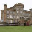
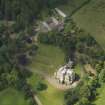
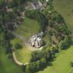
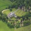
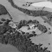
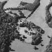
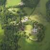
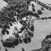
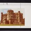
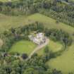
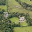
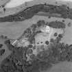
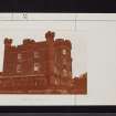
Accessibility

Font Size

100% 150% 200%

Background Colour

Default Contrast
Close Reset

Pricing Change

New pricing for orders of material from this site will come into place shortly. Charges for supply of digital images, digitisation on demand, prints and licensing will be altered. 


Caprington Castle

Castle (Medieval), Tower House (Medieval)

Site Name Caprington Castle

Classification Castle (Medieval), Tower House (Medieval)

Canmore ID 42795

Site Number NS43NW 21

NGR NS 40775 36251

Datum OSGB36 - NGR

Permalink http://canmore.org.uk/site/42795

Ordnance Survey licence number AC0000807262. All rights reserved.
Canmore Disclaimer. © Bluesky International Limited 2025. Public Sector Viewing Terms

Toggle Aerial | View on large map

Digital Images

View from ESE
View from ESEOblique aerial view of Caprington Castle and stables, taken from the SE.Oblique aerial view of Caprington Castle and stables, taken from the NW.Oblique aerial view of Caprington Castle and stables, taken from the SSW.Caprington Castle, Riccarton parish, Kilmarnock and LoudounView from SEDrawing showing view of Caprington Castle from SE. Photographic copy of a page from a 'Visiting Album' kept by Miss Violet A Montgomery, 1888-1909.Caprington Castle, NS43NW 21, Ordnance Survey index card, page number 1, RectoGeneral view from ESEOblique aerial view of Caprington Castle and policies, taken from the NE.Oblique aerial view of Caprington Castle, taken from the SE.Oblique aerial view of Caprington Castle and stables, taken from the ESE.Oblique aerial view of Caprington Castle and stables, taken from the E.Oblique aerial view of Caprington Castle and stables, taken from the ENE.Oblique aerial view of Caprington Castle and stables, taken from the NW.Caprington Castle, NS43NW 21, Ordnance Survey index card, RectoGeneral view from SEOblique aerial view of Caprington Castle and stables, taken from the NNE.Oblique aerial view of Caprington Castle, taken from the WSW.Oblique aerial view centred on the castle, tower-house and stables, taken from the WSW.Oblique aerial view centred on the castle, tower-house and stables with the remains of rig adjacent, taken from the SE.Oblique aerial view centred on the castle, tower-house and stables with the remains of rig adjacent, taken from the ESE.Caprington Castle, NS43NW 21, Ordnance Survey index card, page number 1, RectoOblique aerial view of Caprington Castle and stables, taken from the ESE.Oblique aerial view of Caprington Castle and policies, taken from the ENE.Oblique aerial view of Caprington Castle and stables, taken from the SSW.Oblique aerial view of Caprington Castle and stables, taken from the SSE.Oblique aerial view of Caprington Castle and stables, taken from the NE.Oblique aerial view of Caprington Castle and stables, taken from the WNW.Oblique aerial view of Caprington Castle and stables, taken from the WNW.Oblique aerial view of Caprington Castle and stables, taken from the SE.Oblique aerial view of Caprington Castle and stables, taken from the ENE.Oblique aerial view centred on the castle, tower-house and stables, taken from the NE.Caprington Castle, Riccarton parish, Kilmarnock and LoudounCaprington Castle, NS43NW 21, Ordnance Survey index card, page number 2, RectoCaprington Castle, NS43NW 21, Ordnance Survey index card, page number 2, VersoOblique aerial view of Caprington Castle and stables, taken from the NNW.Oblique aerial view of Caprington Castle and stables, taken from the S.Oblique aerial view of Caprington Castle and stables, taken from the NNE.Oblique aerial view of Caprington Castle walled garden, taken from the SE.Oblique aerial view of Caprington Castle and stables, taken from the SSE.Oblique aerial view of Caprington Castle and stables, taken from the ESE.Oblique aerial view centred on the castle, tower-house and stables, taken from the SSW.Caprington Castle, NS43NW 21, Ordnance Survey index card, Recto

Administrative Areas

  • Council East Ayrshire
  • Parish Riccarton
  • Former Region Strathclyde
  • Former District Kilmarnock And Loudoun
  • Former County Ayrshire

Archaeology Notes

NS43NW 21.00 40775 36251

(NS 4077 3623) Caprington Castle (NR) (restored)

OS 6" map (1970)

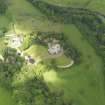
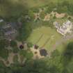
NS43NW 21.01 40958 35987 Gardener's Cottage

NS43NW 21.02 40516 36018 West Lodge

NS43NW 21.03 40645 36188 Stables

NS43NW 21.04 41018 36034 Walled Garden

NS43NW 40.00 4039 3619 Caprington Mains Farm

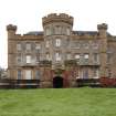
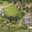
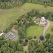
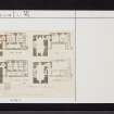
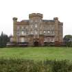
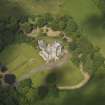
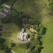
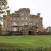
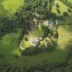
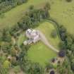
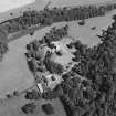
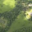
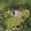
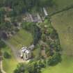
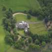
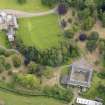
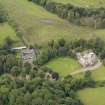
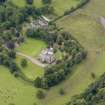
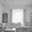
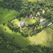
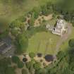
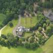
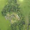
Caprington Castle is a battlemented mansion erected about 1820 by Sir William Cuninghame, who gave it all its present essential features, but embodying a great deal of an earlier fortress, of which original drawings exist in the possession of the owner, dated 1797. The walls of the dining room correspond with the original keep, and the original turnpike stair is still extant.

SDD List 1963.

D MacGibbon and T Ross 1892

The tower which forms the SW part of Caprington Castle is said to be of 15th century date, with 17th-18th and 19th century alterations. The whole has been completely restored and modernised, losing its original character (Col. W W S Cuninghame, owner).

Visited by OS (JLD) 3 October 1962

No change to the previous report; the castle is still the private residence of the Cuninghame family.

Visited by OS (JRL) 3 July 1982.

Architecture Notes

NS43NW 21.00 40775 36251

NMRS REFERENCE

Owner: Colonel Cunninghame

EXTERNAL REFERENCE

Plans: Colonel Cunninghame has drawings dated 1797 which are those published in M & R Dom Arch.

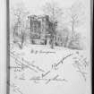
Vignette on map by William Crawford May 1778 in possesion of Colonel Cunninghame. Seen 12/5/85

Patrick Wilson

Caprington Castle (near Kilmarnock). Additions

advertisement for tenders 1829

(Edinburgh Evening Courant, April 30, 1829)

Photographed on behalf of the Buildings of Scotland series (2009).

References

MyCanmore Image Contributions


Contribute an Image

MyCanmore Text Contributions