
Gadgirth, Old Ha'


Castle (Medieval)
Site Name Gadgirth, Old Ha'
Classification Castle (Medieval)
Canmore ID 42765
Site Number NS42SW 3
NGR NS 40588 21907
Datum OSGB36 - NGR
Permalink http://canmore.org.uk/site/42765


- Council South Ayrshire
- Parish Coylton (South Ayrshire)
- Former Region Strathclyde
- Former District Kyle And Carrick
- Former County Ayrshire
NS42SW 3 4057 2190.
(NS 4057 2190) Old Ha' (NR) (rems of)
OS 6" map (1966)
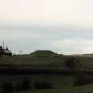
Some remains still exist of the building, commonly called "The Old Ha'," which preceded Gadgirth Castle (NS42SW 1). It was built on a rock jutting into the River Ayr, which surrounded it on two sides. The other two sides were defended by a ditch, crossed by a drawbridge.
J Paterson 1863
All that remains of the "Old Ha" is a stretch of rubble walling, 5.5m long and 3.5m high, situated on the S side of a small rocky promontory. It is evidently of an early date, but its exact period is unknown. To the W is a natural 'ditch' which would form an excellent defence.
Surveyed at 1:2500.
Visited by OS (JLD) 13 May 1954
The promontory is covered by dense vegetation but the remains of the mortared wall and the ditch, on the W side are still evident.
Visited by OS (MJF) 21 October 1980
Field Visit (April 1985)
Old Ha', Gadgirth NS 4057 2190 NS42SW 3
The remains of the Old Ha', which is said to have preceded the tower at Gadgirth (NS42SW 1), occupy the extremity of a rocky promontory projecting from the SE bank of the River Ayr, 500m WNW of Brae of Gadgirth farmsteading. The surviving portion comprises the NE angle, a fragment of lime-mortared masonry (up to 6.5m long overall and 3m high) built directly against the rock outcrop on the SW, and, on the precipitous NE side, the footings of a return wall (2.3m long and up to 1.5m high); the area enclosed measures 8. 7m by 6m. The promontory ( 15m by 8m) is cut off by a natural gully 9m broad and over 1m deep. During the reign of William the Lion (1165-1214) Gadgirth is said to have been the property of Reginaldus de Camera.
RCAHMS 1985, visited April 1985.
(Paterson 1863-6, i, 228).

