
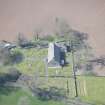
Stair Parish Church


Burial Ground (18th Century), Church (18th Century)
Site Name Stair Parish Church
Classification Burial Ground (18th Century), Church (18th Century)
Canmore ID 42763
Site Number NS42SW 18
NGR NS 43943 23603
Datum OSGB36 - NGR
Permalink http://canmore.org.uk/site/42763


- Council East Ayrshire
- Parish Stair
- Former Region Strathclyde
- Former District Cumnock And Doon Valley
- Former County Ayrshire
NS42SW 18 43943 23603
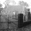
Stair Church dates from 1864.
SDD 1963
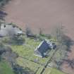
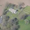
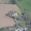
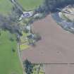
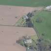
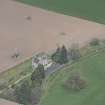
Stair Church is situated about 218m SSW of Stair House (NS42SW 4) and about 300m E of Milton on the E bank of the River Ayr. It is rectangular in plan with an extension block at the NW corner and entrance porch on the S elevation.
The earlier church is depicted on the 1st edition of the OS 6-inch map (Ayrshire, sheet 60, sheet xxxiv) and is described in the Object Name Book (ONB) as ' Established Church - Ph of Stair. It was built in 1706 by the heritors - in a very bad state of repair. One storey in a plain style of architecture and endowed (Name Book 1857). By the date of the 2nd edition 25-inch (1896, ibid, sheet xxxiv.2), the church is rectangular in plan, similar to that of today.
Information from RCAHMS (DE), January 2008
Note
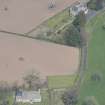
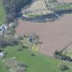
Graveyard depicted on the 1st edition of the OS map (1858). Graveyard then expands to the south on the 2nd edition (1896). The current extent, expanded to the east and northeast, is defined / digitized from orthoimagery provided by Bluesky International Ltd. OS 1km map square NS4323 flown on 5 June 2022.
Information provided by HES (C DeDeo) 17 January 2025.

