
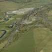
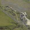
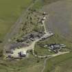
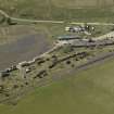
Minnivey Colliery


Colliery(S) (Period Unassigned)
Site Name Minnivey Colliery
Classification Colliery(S) (Period Unassigned)
Alternative Name(s) Minnivey 4 And 5
Canmore ID 42572
Site Number NS40NE 28
NGR NS 4745 0725
NGR Description centred on colliery buildings
Datum OSGB36 - NGR
Permalink http://canmore.org.uk/site/42572


- Council East Ayrshire
- Parish Dalmellington
- Former Region Strathclyde
- Former District Cumnock And Doon Valley
- Former County Ayrshire
NS40NE 28 centred 4745 0725
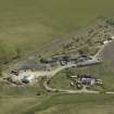
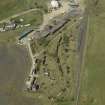
[Location erroneously cited as NS4635 0795]. MINNIVEY Colliery 4 and 5
Location: Dalmellington, near Burnton
Previous Owners: National Coal Board
Sinking/Production Commenced: 1955
Year Closed: 1975
Average Workforce: 378
Peak Workforce: 470
Peak Year: 1962
Other Details: Modern National Coal Board (NCB) complex comprising 2 surface mines, and was expected to work for 40 years, replacing nearby Chalmerston [NS40NE 22.01]. The drifts were 1 in 2.5, extending down to 213m. The colliery became the site of the Scottish Industrial Railway Centre after closure.
M K Oglethorpe 2006.
See also NS40NE 21

