
Lewis, Dun Loch An Duna


Crannog (Neolithic)(Possible), Dun (Prehistoric), Unidentified Pottery (Neolithic)
Site Name Lewis, Dun Loch An Duna
Classification Crannog (Neolithic)(Possible), Dun (Prehistoric), Unidentified Pottery (Neolithic)
Alternative Name(s) Leurbost
Canmore ID 4227
Site Number NB32NE 1
NGR NB 39042 26147
Datum OSGB36 - NGR
Permalink http://canmore.org.uk/site/4227


- Council Western Isles
- Parish Lochs
- Former Region Western Isles Islands Area
- Former District Western Isles
- Former County Ross And Cromarty
NB32NE 1 39037 26143
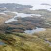
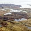
(NB 3903 2614) Dun Loch an Duna (NR)
OS 6"map, Ross-shire, 2nd ed., (1899)
Dun (NR)
OS 6"map, (1965)
'Within 35 yards of the west shore (of Loch an Duna) is a small island surmounted by the remains of a dun. All that now survives is a ruined stone wall built round the water's edge. The rampart has tumbled down, but on the west side a part of the outer face remains in position for a length of some 12ft and a height of about 4ft. Viewed from the shore there seems to be an inner building on the south half of the island .'
RCAHMS 1928, visited 1914.
The remains of an island dun measuring internally 19.7m NE-SW by 18.8m transversely, within a ruined stone wall averaging 1.3m. thich consisting of an inner and outer wall face with rubble core. The outer face remains to a maximum height of 0.7m above water-level on the south side. The footings only of the inner face survive. Within the enclosed area there are secondary buildings, one, sub-rectangular measuring 5.0m x 4.0m internally with a wall c. 1.0m thick and c. 1.0m high, is joined by a wall, 0.9m thick, to a small, heavily overgrown circular structure, c. 1.0m diameter and c. 1.0m high. The name could not be confirmed locally. Resurveyed at 1/2500.
Visited by OS (R L) 5 July 1969.
Field Visit (26 June 1914)
Dun, Loch an Duna, Leurbost.
About ¼ mile east of the road from Stornoway to Crossbost and ¾ mile north-east of Leurbost is a small loch, Loch an Duna, near whose northern end and within 35 yards of the western shore is a small island surmounted by the remains of a dun. All that now survives is a ruined stone wall built round the water's edge. The rampart has tumbled down, but on the west side a part of the outer face remains in position for a length of some 12 feet and a height of about 4 feet. Viewed from the shore there seems to be an inner building on the southern half of the island.
RCAHMS 1928, visited 26 June 1914.
OS map: Lewis xxxiii.

