
Ayr, Cromwell's Fort


Artillery Fortification (17th Century)
Site Name Ayr, Cromwell's Fort
Classification Artillery Fortification (17th Century)
Alternative Name(s) Arran Terrace, Bruce Crescent, Citadel Lane, Mountgomerie Terrace And South Harbour Street, Citadel Fortifications Including Miller's Folly
Canmore ID 41776
Site Number NS32SW 15
NGR NS 3338 2211
Datum OSGB36 - NGR
Permalink http://canmore.org.uk/site/41776


- Council South Ayrshire
- Parish Ayr
- Former Region Strathclyde
- Former District Kyle And Carrick
- Former County Ayrshire
NS32SW 15.00 3338 2211
NS32SW 15.01 333 221 fortifications
NS32SW 15.02 3348 2208 Moat Wall
NS32SW 15.03 3346 2208 Gateway
NS32SW 15.04 3330 2220 Sally Port
NS32SW 15.05 3327 2221 Magazine
NS32SW 15.06 3339 2227 urban excavation; pottery
(NS 3338 2211) Fort (NR)
OS 6" map (1967)
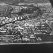
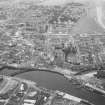
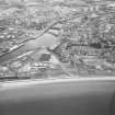
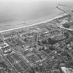
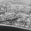
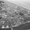
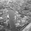
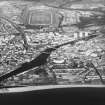
A citadel was built on the peninsula west of Ayr by Cromwell's troops between 1652 and 1654. It covered about 16 acres of land and was protected by a wall 10ft broad and 14ft high with six bastions and six curtain walls. It was protected on the north by the river, on the west by the sea, and on the south and east by a moat 50ft wide at the bastions and 90ft wide at the curtain walls. The barracks, which covered most of the ground, provided quarters for 800 foot soldiers and 200 horse soldiers, excluding officers,and there was stabling for about 220 horses (see Tessin's plan of 1654). A charter of 1663 established the citadel area as the burgh of barony of Montgomeriestoun, but this was merely a parchment burgh.
Some of the stone work had been removed by the end of the 17th century, but very little building took place on the site before 1855, though by 1906 extensive building had taken place. (See sub-sites for details and field reports). (See also NS32SW 112)
W Dodd 1972; H Caldwell, H Fraser and L Lyall 1969; S Cruden 1960
NS 332 223 In May 2000 a watching brief was carried out on landscaping works, including the construction of a footpath/cycle path and public square, adjacent to the northern remains of Ayr's Cromwellian Citadel (NMRS NS32SW 15). The results of the watching brief recorded minimal foundations from the Churchill Barracks and a short section of base foundation of the Citadel wall. (GUARD 867).
Sponsor: South Ayrshire Council.
A K Maule 2001
Publication Account (1977)
The remains of the Cromwellian citadel at Ayr is the best surviving example in Scotland of a fortress of that hue. Cromwellian troops built the citadel in the 1650s on land encompassing not only the area of the old castle but of the parish church as well. Stone for the project was possibly brought by sea from Ardrossan Castle (Dunlop, 1953, 199). The general plan of the fortress can be traced on the ground - the north, northwest, and southwest bastion walls being complete and backed by an earthen platform on the west and southwest. The enclosed area in total is twenty-seven acres - room enough for a garrison of 2000 foot and horse soldiers (Ordnance Survey, Record Cards, Reference NS 32 SW 15). The fortress although short-lived as a military establishment, was raised into the status of a baronial burgh in 1663 after King Charles II granted the area to the Earl of Eglinton. The burgesses of Ayr purchased the charter from the Earl in 1687 and sold it in turn to the Countess of Eglinton in 1727, who tried to encourage diverse industries such as brewing within the citadel precinct In 1755 the citadel passed in ownership to the Kennedies of Culzean.
Information from ‘Historic Ayr: The Archaeological Implications of Development’, (1977).

