
Larkfield, Covenanters' Well And Pulpit Rock


Preaching Site (17th Century), Spring (Period Unassigned)
Site Name Larkfield, Covenanters' Well And Pulpit Rock
Classification Preaching Site (17th Century), Spring (Period Unassigned)
Alternative Name(s) Larkfield Industrial Estate; Earnhill Road
Canmore ID 41323
Site Number NS27NW 2
NGR NS 2342 7621
NGR Description NS 2342 7621 and NS 2342 7623
Datum OSGB36 - NGR
Permalink http://canmore.org.uk/site/41323


- Council Inverclyde
- Parish Inverkip
- Former Region Strathclyde
- Former District Inverclyde
- Former County Renfrewshire
NS27NW 2 2342 7621 and 2342 7623
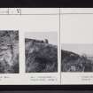
(NS 2342 7621) Covenanters' or White's Well (NR)
(NS 2342 7623) Pulpit Rock (NAT)
OS 6" map (1970)
Coventicles were held here in the late 17th century. A large outcrop of rocks forms a natural pulpit known as the 'Pulpit Rock' and nearby was a supply of clear water known as the 'Convenanters Well', reference to which was made as early as 1698. This well is also known as "White's Well" as the name 'J White' is inscribed on the large rock which covers the opening; apparently he was one of the Covenanters who met here. The well was probably used for baptism; it is in a cavity under the rock, first rising perpendicular, then sloping inwards, forming a natural tablet on which is incised the date '1698', the words 'White's Well', and the letters 'B O M'.
The Pulpit Rock was a natural pulpit with book-board, which was destroyed by vandals in 1947; behind it were two steps. On the remaining outcrop of rocks were many and varied masons' marks, even cup-and-ring marks, which were erased by a vandal in 1951.
J B Scrymgeour articles in Gourock Times, 23 May 1952 and 6 June 1952.
Covenanters' or White's Well: This is a spring which has obviously been used as a well. A massive rock covers the opening, and the sides have the appearance of having been artificially constructed.
Pulpit Rock: situated 11.0m N of the above. Neither the symbols nor the steps referred to above can now be seen. It is simply a free-standing stone.
Visited by OS (JLD), 4 October 1952.

