
Lewis, Great Bernera, Dun Stuigh


Broch (Iron Age)(Possible), Galleried Dun (Iron Age)
Site Name Lewis, Great Bernera, Dun Stuigh
Classification Broch (Iron Age)(Possible), Galleried Dun (Iron Age)
Canmore ID 4122
Site Number NB14SE 2
NGR NB 15406 40261
Datum OSGB36 - NGR
Permalink http://canmore.org.uk/site/4122


- Council Western Isles
- Parish Uig
- Former Region Western Isles Islands Area
- Former District Western Isles
- Former County Ross And Cromarty
NB14SE 2 15406 40261
(NB 1540 4025) Dun Stuigh (NR)
OS 6" map, (1965)
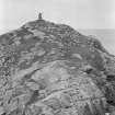
The remains of Dun Stuigh, a probable broch, lie on the outer extremity of a narrow, rocky promontory, isolated by a deep cleft which makes access difficult. It has measured 45' in external diameter with walls varying from 9' to 10' in thickness. The outer face of the wall is traceable all round except on the NE, and the best preserved part, to the SE shows only 3' in height of building in position; the interior is filled with tumbled stones. The doorway has possibly been in the NE arc towards the loch, there being slight indications of built jambs 3'3" apart at this place. A gallery in the body of the wall can be seen at different places; at the SE a short length of the outer part of the wall, 2'10" thick remains in position, and on the northern arc, a part of the inner portion of the wall shows a thickness of 4', but the stones are here slightly displaced, and the original thickness must have been rather less.
RCAHMS 1928, visited 1914.
Dun Stuigh, as described by the RCAHM, except that it measures 14.2m N-S by 13.2m E-W. Part of the outer face on the E and W sides has been eroded by the sea. Though the walls are well built and appear to follow a regular curve, it is more likely to be a galleried dun, due to its small size, shape and thickness of walls (c. 3.0m), and the fact that the E entrance lies on its shorter axis. Name still known locally.
Re-surveyed at 1/10,560.
Visited by OS (N K B), 22 June 1969.
Field Visit (9 July 1914)
Dun Stuigh, Great Bernera.
On the northern rocky shore of Great Bernera, looking out to the island of Little Bernera and across the mouth of East Loch Roag to Carloway, is a narrow rocky promontory, with its extremity almost cut off by a deep cleft in the rock, which makes it difficult of access. On the summit of this almost isolated rock, about 40 yards from its southern margin and some 30 feet from its northern extremity, at an elevation of about 30 feet above the high-watermark, are the remains of a circular dun of drystone masonry, probably a broch, Dun Stuidh, measuring 45 feet in diameter externally and 26 feet inside, the wall varying from 9 to 10 feet in thickness. The outer face of the wall is traceable all round except to the north-east, and the best preserved part, to the south-east , shows only 3 feet in height of building in position; the interior is filled with tumbled stones. The doorway has possibly been in the north-eastern arc towards the loch, there being slight indications of built jambs 3 feet 3 inches apart at this place.
A gallery in the body of the wall can be traced at different places; at the south-east a short length of the outer part of the wall, 2 feet 10 inches thick, remains in position, and in the northern arc a part of the inner portion of the wall shows a thickness of 4 feet , but the stones are here slightly displaced, and the original thickness must have been rather less.
RCAHMS 1928, visited 9 July 1914.
OS map: Lewis xvii (unnoted)
Publication Account (2007)
NB14 2 DUN STUIGH
NB/1540 4025
This probable broch or galleried dun in Uig, Lewis, stands on the north shore of Great Bernera island, on the end of a narrow, rocky promontory, part which is cut off by a deep cleft making access difficult. The broch itself is on the isolated knoll beyond the cleft, and is about 9.15m (30 ft) above the water. A circular building can be traced, of which the overall diameter was assessed origin-ally as 13.73m (45 ft) [2], but more recently as varying between 14.2m north-south and 13.2m east-west [1]. The wall thickness appears to vary from 2.75 to 3.05m (9-10 ft). An entrance may have been in the north-east arc and there are slight signs of built jambs there, 99cm (3 ft 3 in) apart. A mural gallery is traceable at different points. The structure appears rather small for a broch [1].
Dimensions: external diameter 13.73m (45 ft), internal 7.93m (26 ft): the wall proportion is therefore 42.2%.
Sources: 1. NMRS site no. NB 14 SE 2: 2. RCAHMS 1928, 20, no. 70.
E W MacKie 2007

