
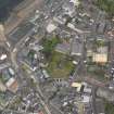
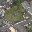
Largs, Manse Court, Largs Old Parish Church, Skelmorlie Aisle And Burial Ground


Burial Aisle (17th Century), Burial Ground (Medieval), Church (19th Century), Church (Medieval)
Site Name Largs, Manse Court, Largs Old Parish Church, Skelmorlie Aisle And Burial Ground
Classification Burial Aisle (17th Century), Burial Ground (Medieval), Church (19th Century), Church (Medieval)
Alternative Name(s) St Columba's Church; Largs Old Kirk; Bellman's Close; Cemetery Wall And Gate Piers
Canmore ID 41159
Site Number NS25NW 13
NGR NS 20265 59441
Datum OSGB36 - NGR
Permalink http://canmore.org.uk/site/41159


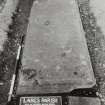
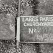
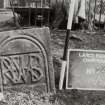
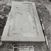
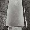
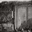
![View of flatstone.
Insc: "Heu. Hal. Elezabth Iameson 1703 I.IXI.B 1755 Joiin Jameson U Jean Morris. Janet Jamieson Wife of Thomas Underwood died 6th Dec 1847 aged 80 years their son William died 16th May 1847 aged 42 years. Isabella Bryden second wife of Thomas Underwood died August 24th 1854 aged 26 years and there [sic] son Walter aged 10 months."
Largs Parish Churchyard no 108](http://i.rcahms.gov.uk/canmore/l/SC02534107.jpg)


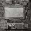


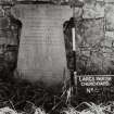
![View of flatstone.
Insc: "Heu. Hal. Elezabth Iameson 1703 I.IXI.B 1755 Joiin Jameson U Jean Morris. Janet Jamieson Wife of Thomas Underwood died 6th Dec 1847 aged 80 years their son William died 16th May 1847 aged 42 years. Isabella Bryden second wife of Thomas Underwood died August 24th 1854 aged 26 years and there [sic] son Walter aged 10 months."
Largs Parish Churchyard no 108](http://i.rcahms.gov.uk/canmore/s/SC02534107.jpg)


First 100 images shown. See the Collections panel (below) for a link to all digital images.
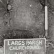
- Council North Ayrshire
- Parish Largs
- Former Region Strathclyde
- Former District Cunninghame
- Former County Ayrshire
NS25NW 13.00 20265 59441
(NS 2026 5943) St Columba's Ch (NR) (Remains of)
Skelmorlie Aisle (NR)
OS 6" map (1856)
NS25NW 13.01 NS 20247 59447 Brisbane Aisle
NMRS Microfilm and Microfiche Collection
Monumental Inscriptions Within Cunninghame District.
Copyright: Cunninghame District Council
Acc No 1990/57
Reel 2 (Largs), accompanied by index on microfiche.
(Undated) information in NMRS.
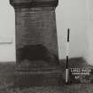
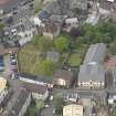
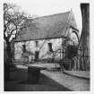
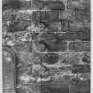
Largs parish church, which was dedicated to St Columba (Orig Paroch Scot 1851) and which belonged to Paisley Abbey, first appears on record in 1263. The present church (at NS 2045 5962) was built in 1812, when its predecessor, in the now disused burial ground, was taken down. A fragment of the S wall containing a monument to the Boyles of Kelburne was allowed to remain, though it had to be removed later for burials. 'The church was of unknown age and of great strength, the piece of wall mentioned above being about 4ft thick and very compact. It is therefore probable that the demolished church may have, in whole or in part, formed the original church of Largs.
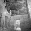
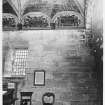
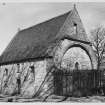
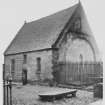
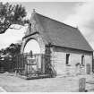
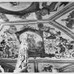
The only part of the church now remaining is the Skelmorlie aisle, formerly the N transept. This was built by Sir Robert Montgomery of Skelmorlie in 1636 to contain a notable Renaissance monument; it is also noteworthy for its fine painted ceiling.
J Shedden-Dobie 1889; W Dobie and R D Wilson 1889; D MacGibbon and T Ross 1892; G Hay 1957
The Skelmorlie Aisle is generally as described. It is in good condition.
Visited by OS (DS) 20 September 1956
No change to previous field report.
Visited by OS (WDJ) 27 October 1964
OS 25" 1856 shows the pecked outline of the church as a building some 22.0m E-W by 6.0m with the Skelmorlie Aisle extending to the N.
Information from OS Recorder (IF) 19 July 1977
No change. There is no ground trace of the building indicated on OS 1st edition 25".
Visited by OS (JRL) 2 February 1983.
Scheduled as 'Skelmorlie Aisle and Largs Old Churchyard, west of Lade Street'.
Information from Historic Scotland: amended entry in the Schedule of Monuments, dated 3 December 2009.
Publication Account (1985)
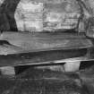
The Skelmorlie burial-aisle is all that now survives of the former 'old kirk' of Largs and is renowned for its unusual burial monument and fine painted ceiling. Sir Robert Montgomery ofSkelmorlie added the aisle to the church in 1636 to serve as a burial place for himself and his wife, Dame Margaret Douglas, and when the church was demolished in 1802 the aisle was left as a freestanding building.
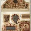
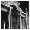
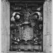
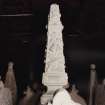
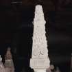
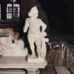
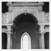
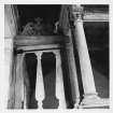
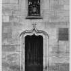
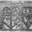
The aisle is entered from the west through an unusual doorway above which there is a painted amorial panel bearing the arms of Montgomery and Eglinton (for Sir Robelt) and those of Douglas and Mar (for Dame Margaret). Inside there is an elaborate Renaissance style burial monument which forms the focal point of the interior. It is without parallel in Scotland and is remarkable for the refinement of its Netherlandish detail. Carved from local freestone, it takes the form of a triumphal archway surmounted by strapwork, finials and chembs, and is raised on a dais or gallery over a burial-vault which still contains the lead coffins of Sir Robert and his wife. Originally, the monument would have been brightly painted, like the armorial panel above the doorway, and was designed to include a pair of recumbent effigies but either these have not survived or they were never added. Today, an iron helm has been placed in the position that should have been occupied by the effigies. The design of the monument is probably based on Anglo-Dutch models and engravings, the construction itself being carried out by local craftsmen.
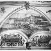
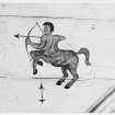
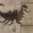
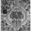
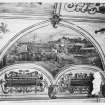
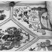
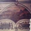
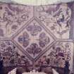
The ceiling of the aisle is a boarded barrel-vault richly embellished with painted decoration, in a style fashionable during the first half of the 17th century. It is, however, rare to see such decoration in a church as it is normally found only in secular contexts. The framework of the decoration is designed to imitate a stone vault, with painted scenes filling the spaces formed by the ribs. Included within the decoration there are texts from the Geneva Bible (popular in Scotland prior to the introduction of the King James version), signs of the zodiac and the imaginary arnlS of the tribes of Israel. Above the texts there are six scenes; those at the corners represent the four seasons, with Summer (behind and to the left of the monument) showing the aisle and the old kirk, while at the centre there are two prospects of Largs itself An inscription gives the name of the painter as J Stalker and the date 1638.
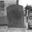
The graveyard contains at least two other features of note. Firstly, the rectangular burial-vault of the Brisbane family which lies to the west of the custodian's office. Sir Thomas Brisbane was appointed governor-general of New South Wales, Australia in 1821, and gave his name to the state capital. Secondly, tucked in between the Brisbane vault and the graveyard wall, there is a reconstructed bronze-age cist, moved to its present position after discovery elsewhere in the parish.
Information from ‘Exploring Scotland’s Heritage: The Clyde Estuary and Central Region’, (1985).
Project (18 August 2014 - 20 August 2014)
NS 20265 59441 The Skelmorlie Aisle was built in 1636 and formed the N transept of the medieval parish church of Largs. The body of the church was demolished in the early 19th century, leaving the aisle standing alone in the graveyard. A geophysical survey was undertaken, 18–20 August 2014, of the graveyard surrounding the aisle and the northern extension to the graveyard. The survey aimed to identify the position of the current drains and areas bereft of archaeology or burials where new drains and a sump might be placed. It was also hoped a better understanding would be gained of the plan of the demolished church. A resistance survey was carried out over all available areas in the graveyard and northern
extension, while a Ground Penetrating Radar (GPR) survey was limited to the northern extension to the graveyard and the area immediately surrounding the aisle.
Although the resistance survey identified some responses of potential significance it did not clearly identify the footprint for the former church. The GPR survey data are confused by extant graves. However, the survey does appear to have detected possible drainage features and potentially
identified limited sections of possible foundations associated with the earlier church. Additional responses suggestive of further buried structural features to the N of the aisle were also noted.
Archive: Rose Geophysical Consultants
Funder: Historic Scotland
Susan Ovenden – Rose Geophysical Consultants
(Source: DES)
Resistivity (18 August 2014 - 20 August 2014)
NS 20265 59441 A resistance survey was carried out over all available areas in the graveyard and northern
extension. Although the resistance survey identified some responses of potential significance it did not clearly identify the footprint for the former church.
Archive: Rose Geophysical Consultants
Funder: Historic Scotland
Susan Ovenden – Rose Geophysical Consultants
(Source: DES)
Ground Penetrating Radar (18 August 2014 - 20 August 2014)
NS 20265 59441 Ground Penetrating Radar (GPR) survey was limited to the northern extension to the graveyard and the area immediately surrounding the aisle. The GPR survey data are confused by extant graves. However, the survey does appear to have detected possible drainage features and potentially identified limited sections of possible foundations associated with the earlier church. Additional responses suggestive of further buried structural features to the N of the aisle were also noted.
Archive: Rose Geophysical Consultants
Funder: Historic Scotland
Susan Ovenden – Rose Geophysical Consultants
(Source: DES)

