
Great Bernera, Dun Barraglom


Broch (Iron Age)(Possible)
Site Name Great Bernera, Dun Barraglom
Classification Broch (Iron Age)(Possible)
Canmore ID 4115
Site Number NB13SE 5
NGR NB 1677 3435
Datum OSGB36 - NGR
Permalink http://canmore.org.uk/site/4115


- Council Western Isles
- Parish Uig
- Former Region Western Isles Islands Area
- Former District Western Isles
- Former County Ross And Cromarty
NB13SE 5 1677 3435
(NB 1677 3435) Dun (NR) (Remains of).
OS 6" map, (1965)
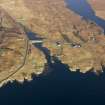
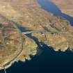
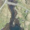
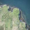
A mere fragment of Dun Barraglom remains on a small promontory rising 8' above HWM about 300 yards E of the pier. It has probably been a circular structure with an external diameter of 52'. A few of the outer foundation stones are still traceable.
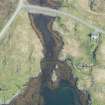
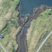
There are slight indications of a ditch across the neck of the promontory.
RCAHMS 1928, visited 1914.
All that remains of Dun Barroglom are the footings of the outer face occasionally visible except in the E, indicating an overall diameter of 15.0m. Apart from the vague footings of a later building within and another abutting the N side, no internal features are visible.
There are no indications of a ditch; what the RCAHMS has seen is a boat noost and the remains of a building, which give the impression of a ditch. There are traces of a wall along the W edge of the headland, but this may be later.
The remains tend to suggest a broch rather than a dun. The name is still known locally.
Re-surveyed at 1/2500.
Visited by OS (N K B) 22 June 1969.
Scheduled with fish trap at NB 167 344 (for which see NB13SE 19) as 'Rubna nan Sidhean, cupmarked rocks and fish trap, Kirkibost'.
Information from Historic Scotland, scheduling document dated 9 October 1992.
Field Visit (19 June 1914)
Dun, Barraglom, Great Bernera.
At the township of Barraglom, on the southern shore of Bernera, about 300 yards east of the new pier, on a small promontory rising 8 feet above high-water mark, is the mere fragment of Dun Barraglom, which has probably been a circular structure with a diameter externally of some 52 feet. A few of the outer foundation stones are still traceable. There are slight indications of a ditch across the neck of the promontory.
RCAHMS 1928, visited 19 June 1914.
OS map: Lewis xxiv.
Publication Account (2007)
NB13 2 DUN BARRAGLOM
NB/1677 3435
Little is left of this probable broch on Great Bernera, Uig, Lewis, which is situated on a small promontory (rising to 2.44m (8 ft) above high water mark) on the south coast of the island. The building appears to have been circular, with an overall diameter of 15.86m (52 ft) [2]. A few of the foundation stones of the outer face are traceable and there are slight signs of a ditch across the neck of the promontory. Although originally classed as a dun [2] the size and circular plan might imply that the building was a broch [1]. The possible ditch across the neck of the promontory [2] has been re-interpreted as a boat noost [1].
Sources: 1. NMRS site no. NB 13 SE 5: 2. RCAHMS 1928, 22, no. 77.
E W MacKie 2007

