
Montfode Castle


Tower House (Medieval)
Site Name Montfode Castle
Classification Tower House (Medieval)
Canmore ID 41101
Site Number NS24SW 1
NGR NS 22612 44129
Datum OSGB36 - NGR
Permalink http://canmore.org.uk/site/41101


- Council North Ayrshire
- Parish Ardrossan
- Former Region Strathclyde
- Former District Cunninghame
- Former County Ayrshire
NS24SW 1 22612 44129
(NS 2261 4412) Montfode Castle (NR) (remains of)
OS 25" map (1969)
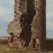
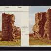
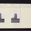
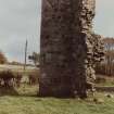
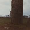
Montfode Castle, "a pretty dwelling" according to Pont was in ruins in the mid-19th Century, the only part remaining in 1856 being a circular tower at the N angle, and a small part of the NE wall. Paterson states that it originally consisted of a "large oblong square tower", demolished within memory to build a threshing mill.
J Dobie 1876; J Paterson 1847; Name Book 1856
The ruins of Montfode Castle are as described in the Ordnance Survey Name Book (ONB). The tower stands to a height of some 8m and has an interior diameter of 2.0m. The wall, on the S of the tower, is about 7m high and 2.0m long. Both tower and wall are of rubble masonry and 0.7m thick. The position of the tower upon an exterior angle, suggests that the building was of Z-plan, dating from the latter half of the 16th century.
Visited by OS (DS) 22 January 1957
No change.
Visited by OS (JRL) 13 October 1982.

