
Blackshaw Moor


Enclosure (Period Unassigned)
Site Name Blackshaw Moor
Classification Enclosure (Period Unassigned)
Canmore ID 41010
Site Number NS24NW 22
NGR NS 2313 4817
Datum OSGB36 - NGR
Permalink http://canmore.org.uk/site/41010


- Council North Ayrshire
- Parish West Kilbride
- Former Region Strathclyde
- Former District Cunninghame
- Former County Ayrshire
NS24NW 22 2313 4817.
Smith notes a stone circle on Blackshaw Moor, near cup-and-ring marked rock NS24NW 19; Lamb is doubtless referring to the same site, mentioning "indistinct traces of a fort or stone circle on Blackshaw Moor, a little beyond Hopeton."
J Smith 1895; J Lamb 1896
NS 2313 4815. Traces of a sub-circular enclosure, about 26m in diameter, may be seen on the slopes of a small knoll, 180m S of NS24NW 19. Large stones are visible in the surrounding bank which is spread to a width of 3m and a maximum height of 0.3m. No entrance is visible.
Visited by OS (DS) 7 September 1956
This feature appears to be the remains of an old livestock enclosure of no great age.
Visited by OS (WDJ) 18 November 1965
NS 2313 4817. This enclosure is of archaeological significance, and is possibly the scant remains of a homestead. Situated in a non-defensive position on a low, reed-covered rise at 170m OD, enough survives to suggest that that the earth and rubble walling (2.0 to 2.5m wide) was retained by substantial inner and outer facing-stones, and that there was probably an entrance on the slightly uphill (N) entrance adjacent to a rock outcrop. The only measurable height to this bank or wall is at a point on the N arc where an inner scarp 0.3m high survives.
Seen in an earlier state of preservation, with, probably, more grounder stones evident, Smith's description of a stone circle here is understandable. OS air photographs (80/122: 37-8, flown 1980) confirm that a narrow rig pattern on the W overlaid the W half of this site.
Surveyed at 1:2500.
Visited by OS (JRL) 11 November 1982
Desk Based Assessment (November 2014 - March 2015)
A desk-based assessment and reconnaissance field survey have been carried out for the Proposed Development Site. Seventeen cultural heritage assets (sites and features) have been identified within the Proposed Development Site. These range in date from the early prehistoric (Neolithic/Bronze Age) to the post-medieval period and include a well-preserved cup and ring marked rock, which is a Scheduled Monument, several prehistoric artefact find-spots, a possible prehistoric enclosure and later post-medieval settlement and agrarian activity.
Funder: Community Windpower Ltd.
CFA Archaeology Ltd
OASIS ID: cfaarcha1-260699
Field Visit (10 November 2014 - 1 March 2015)
Canmore and the HER record that the scant remains of a possible enclosure is present at this location. The feature was first recorded in the late 1890s (Smith 1895, Lamb 1896) and was interpreted at the time as the remains of a possible fort or stone circle. Field survey carried out in 1957 by the Ordnance Survey recorded that the enclosure was located on the slopes of a small knoll. It was sub-circular in plan and measured 26 m in diameter; large stones were visible in the surrounding bank of the enclosure, spread to 3 m wide and 0.3 m high, and no entrance was visible. Subsequent field survey by the Ordnance Survey in 1965 recorded that the enclosure appeared to be the remains of an old livestock enclosure of no great age.
Later field survey in 1982 by the Ordnance Survey recorded that the enclosure is situated in a non-defensive position on a low, reed-covered rise at 170 m AOD. Enough survived of the enclosure to suggest that the earth and rubble walling (2m – 2.5m wide) was retained by substantial inner and outer facing-stones, and that there was probably an entrance on the slightly uphill northern side adjacent to a rock outcrop. The only measurable height to the enclosure bank was at a point on the northern arc where an inner scarp 0.3m high survived. Narrow rig and furrow remains are visible on aerial photographs from 1980 overlying the western half of this site.
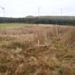
Current field survey identified the enclosure (5a) just south of a rocky knoll. The remains of the enclosure are poorly preserved and difficult to define, although fragments of turf-covered bank are just visible on the northern and southwestern arcs, suggesting a bank c.3 m wide. The enclosure is roughly sub-circular in plan measuring c.25 m in diameter. The interior of the enclosure was full of dense reeds and no obvious internal features were visible. What maybe a possible entrance is visible on the north side of the enclosure (as previously recorded by the Ordnance Survey in 1982); however a well worn sheep track leads up around the rocky outcrop knoll, to the north of the enclosure, and crosses the northern edge of the enclosure at the location of the ‘entrance’ and it maybe that the ‘entrance’ recorded in 1982 may actually be a result of erosion of the enclosure bank at this point from animal trampling. No visible upstanding remains of rig and furrow (as previously noted from aerial photographs from 1980, see above) were identified in the area.
Information from OASIS ID: cfaarcha1-260699 (M Hastie) 2015

