
Following the launch of trove.scot in February 2025 we are now planning the retiral of some of our webservices. Canmore will be switched off on 24th June 2025. Information about the closure can be found on the HES website: Retiral of HES web services | Historic Environment Scotland
Dalquharran Colliery


Settlement (Prehistoric)(Possible)
Site Name Dalquharran Colliery
Classification Settlement (Prehistoric)(Possible)
Alternative Name(s) Burnside
Canmore ID 40867
Site Number NS20SE 17
NGR NS 26753 01796
Datum OSGB36 - NGR
Permalink http://canmore.org.uk/site/40867


- Council South Ayrshire
- Parish Dailly
- Former Region Strathclyde
- Former District Kyle And Carrick
- Former County Ayrshire
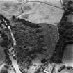
The cropmarks of what is probably a curvilinear ditched settlement were recorded during aerial survey, immediately above and to the E of the B741 road between Dailly and Lochmodie Bridge. Only a small part of the circuit of the ditch is visible, but the area enclosed by the ditch measures at least 25m NNW and SSE by at least 20m transversely. The entrance lies on the ENE and cropmarking indicates a gap of about 4m. The ditch widens towards the entrance on both sides. There are cropmarks immediately to the N of the site suggesting a further smaller enclosure with rounded corners.
Information from RCAHMS (MMB) 13 April 2004
Note (1983)
Dalquharran Colliery NS 267 018 NS20SE
Cropmarks on the E side of the public road (B741) at Dalquharran Colliery reveal what may be the SE side and the entrance of an enclosure.
RCAHMS 1983
Aerial Photographic Transcription (31 October 2003 - 5 November 2003)
An aerial transcription was produced from oblique aerial photographs. Information from Historic Environment Scotland (BM) 31 March 2017.

