
Kirkoswald, Old Parish Church And Graveyard


Burial Ground (Medieval) - (Post Medieval), Church (Medieval), War Memorial (20th Century) (1921)
Site Name Kirkoswald, Old Parish Church And Graveyard
Classification Burial Ground (Medieval) - (Post Medieval), Church (Medieval), War Memorial (20th Century) (1921)
Alternative Name(s) Kirk Oswald; Kirkoswald, Ruin Of Old Church And Graveyard; War Memorial
Canmore ID 40844
Site Number NS20NW 2
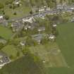
NGR NS 23884 07511
Datum OSGB36 - NGR
Permalink http://canmore.org.uk/site/40844


- Council South Ayrshire
- Parish Kirkoswald
- Former Region Strathclyde
- Former District Kyle And Carrick
- Former County Ayrshire
NS20NW 2 23884 07511
(NS 2387 0750) Kirk Oswald (NR) (remains of)
OS 1:10000 map (1972)
Not to be confused with Kirkoswald parish church (NS 2396 0736), for which see NS20NW 19.
Kirk Oswald was dedicated to St Oswald (Oswald, king of Northumbria, slain in battle in 641 (W J Watson 1926)). It was given to Paisley Abbey by the Earl of Carrick; the grant was confirmed by Florence, Bishop-elect of Glasgow (1202-6). Now roofless, it stands within a burial ground. It is a simple oblong on plan, measuring 93ft 6ins by 28ft 4ins externally. It seems to have consisted of plain walls, but within modern times it has been converted into a mausoleum by building up the windows and adding buttresses to the S side. The pointed blank windows and doorway in the S wall are also modern additions. Though at first sight the building appears ancient, closer examination shows that it has been modernised beyond recognition. It was replaced in 1777 by the present church (at NS 2396 0736).
D MacGibbon and T Ross 1897; H Scott 1920; C A R Radford 1974; G Hay 1957
This church, now roofless and disused, is a simple oblong building, as described, composed of mortared rubble masonry, now almost completely ivy-covered. It stands on ground sloping N-S.
Visited by OS (JD) 30 November 1955
'Kirk Oswald': name verified. Prior to 1970, a roofed, stone-built storehouse was built within the central area of the church shell, further obscuring what original detail remains. It is otherwise as described.
The churchyard has recent burials and is well tended. Part of the Burns Heritage Trail, it has the graves of Hugh Rodger, Douglas Graham (Tam O' Shanter) and John Davidson (Souter Johnnie).
Visited by OS (JRL) 31 May 1977.
Field Visit (April 1982)
Kirkoswald, Old Parish Church and Burial-ground NS 238 075 NS20NW 2
This church is on record in the early 13th century although the present ruinous building appears to be largely of post-Reformation date and the doorway and most of the windows are 19th-century restorations. It was replaced by a new church (150m to the SSE) in 1777.
RCAHMS 1983, visited April 1982
(Stat. Acct., x, 1794, 477; Paterson 1863-6, ii, 283-5; Chalmers 1887-1902, vi, 532-3; MacGibbon and Ross, 1896-7, iii, 582; Cowan 1967, 123).
Photographic Record (1986)
Recording of gravestones in the churchyard of Kirkoswald Old Parish Church, Ayrshire, by Mrs Betty Willsher 1986.

