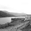
 |
On-line Digital Images |
SC 461527 |
Papers of Professor John R Hume, economic and industrial historian, Glasgow, Scotland |
West Loch Tarbert, 'New' Pier
View from E |
24/4/1976 |
Item Level |
|
|
Manuscripts |
MS 749/2078 |
Papers of Professor John R Hume, economic and industrial historian, Glasgow, Scotland |
J R Hume Industrial/CBA cards. Filed under Inverness-shire county, Harris parish, New Pier, West Loch Tarbert. Photograph noted. (See NMRS MS/749 entry for Collection description) |
|
Item Level |
|
|
Photographs and Off-line Digital Images |
H 89235 CS |
W Black |
Oblique aerial view of Kennacraig Pier, West Loch, Artgyll, taken from the SW |
10/1974 |
Item Level |
|
 |
On-line Digital Images |
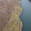
DP 110497 |
RCAHMS Aerial Photography Digital |
General oblique aerial view of the remains of the townships of Lechcan, West Tarbert and Tota Glas, with associated head dyke and piers on the shores of Loch a' Siar, Harris, taken from the NW. |
14/11/2011 |
Item Level |
|
 |
On-line Digital Images |
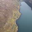
DP 110498 |
RCAHMS Aerial Photography Digital |
General oblique aerial view of the remains of the townships of Lechcan, West Tarbert and Tota Glas, with associated head dyke and piers on the shores of Loch a' Siar, looking towards Tarbert, Harris, taken from the NW. |
14/11/2011 |
Item Level |
|
 |
On-line Digital Images |
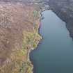
DP 110499 |
RCAHMS Aerial Photography Digital |
General oblique aerial view of the remains of the townships of Lechcan, West Tarbert and Tota Glas, with associated head dyke and piers on the shores of Loch a' Siar, looking towards the village of Tarbert, Harris, taken from the NW. |
14/11/2011 |
Item Level |
|
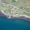 |
On-line Digital Images |
DP 235674 |
Historic Environment Scotland |
Oblique aerial view. |
3/6/2016 |
Item Level |
|
 |
On-line Digital Images |
SC 2345115 |
Records of the Ordnance Survey, Southampton, Hampshire, England |
Harris, West Loch Tarbert, Pier, NB10SW 6, Ordnance Survey index card, Recto |
c. 1958 |
Item Level |
|