
Pricing Change
New pricing for orders of material from this site will come into place shortly. Charges for supply of digital images, digitisation on demand, prints and licensing will be altered.
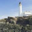
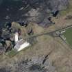
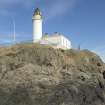
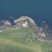
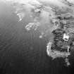
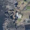
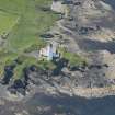
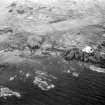
Turnberry Lighthouse And Keepers' Houses


Lighthouse (19th Century), Lighthouse Keepers House(S) (19th Century)
Site Name Turnberry Lighthouse And Keepers' Houses
Classification Lighthouse (19th Century), Lighthouse Keepers House(S) (19th Century)
Alternative Name(s) Turnberry Point Lighthouse; Firth Of Clyde; Outer Clyde Estuary
Canmore ID 40584
Site Number NS10NE 4
NGR NS 19629 07210
Datum OSGB36 - NGR
Permalink http://canmore.org.uk/site/40584


- Council South Ayrshire
- Parish Kirkoswald
- Former Region Strathclyde
- Former District Kyle And Carrick
- Former County Ayrshire
NS10NE 4 19629 07210
Turnberry Lighthouse [NAT]
OS 1:10,000 map, 1972.
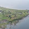
For (surrounding) remains of Turnberry Castle, see NS10NE 1.
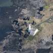
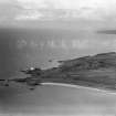
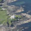
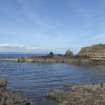
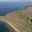
This shore lighthouse on the E side of the Outer Clyde Estuary was built by David and Thomas Stevenson, being one of the 29 that they built together between 1854 and 1878. It was established in 1873, and was automated (as a major automatic light) in 1986; it has since been sold to the golf course.
This lighthouse has also served as the land base for the helicopter relief of Ailsa Craig lighthouse.
Information from RCAHMS (RJCM), 28 June 2006.
R W Munro 1979; K Allardyce and E M Hood 1986; K Allardyce 1998; S Krauskopf 2001.
Photographed by RCAHMS Threatened Buildings Survey prior to restoration as accomodation space by the Turnberry Hotel.
2008.
Note (28 June 2006)
This shore lighthouse on the E side of the Outer Clyde Estuary was built by David and Thomas Stevenson, being one of the 29 that they built together between 1854 and 1878. It was established in 1873, and was automated (as a major automatic light) in 1986; it has since been sold to the golf course.
This lighthouse has also served as the land base for the helicopter relief of Ailsa Craig lighthouse.
Information from RCAHMS (RJCM), 28 June 2006.
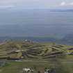
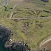
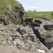
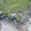
Archaeological Evaluation (2 December 2014 - 25 May 2016)
NS 1962 0721 Archaeological works were undertaken at Turnberry Golf Course, between 2 December 2014 and 25 May 2016. Phase 1 comprised a walkover survey and evaluation centred around Turnberry Castle (Canmore ID: 40581), Turnberry Lighthouse and Keeper’s Houses and the adjacent Walled Garden (Canmore ID: 40584). Phases 2 to 5 related to locating and excavating historical service trenches leading towards the castle and lighthouse along with various watching briefs conducted during the installation of the 9th green and the removal of the walled garden. An evaluation and watching brief undertaken during the installation of stairs and paving on the lighthouse’s western terrace included the re-excavation of a trench originally investigated in 2008.
Potentially significant archaeological remains of indeterminate date were uncovered just to the S of the walled garden while a possible entrance to the castle was recorded beneath the current trackway. Two intercutting ditches were excavated within the trench on the western terrace, however, it remains unclear whether they relate to the lighthouse or castle. Many modern services were located within the confines of the castle wall.
Archive: NRHE (intended)
Funder: SLC Turnberry Ltd
Steven Black – Clyde Archaeology
(Source: DES Volume 21)

