
Turnberry Castle


Castle (Medieval)
Site Name Turnberry Castle
Classification Castle (Medieval)
Alternative Name(s) Bruce's Castle; Firth Of Clyde; Outer Clyde Estuary
Canmore ID 40581
Site Number NS10NE 1
NGR NS 19652 07221
Datum OSGB36 - NGR
Permalink http://canmore.org.uk/site/40581


First 100 images shown. See the Collections panel (below) for a link to all digital images.
- Council South Ayrshire
- Parish Kirkoswald
- Former Region Strathclyde
- Former District Kyle And Carrick
- Former County Ayrshire
NS10NE 1 19652 07221
(NS 1965 0722) Turnberry Castle (NR) (remains of)
OS 1:10000 map (1972).
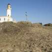
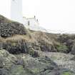
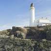
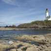
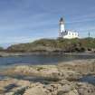
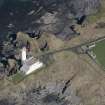
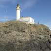
For Turnberry Lighthouse (within the area of the castle), see NS10NE 4.
EXTERNAL REFERENCE:
National Library: Earnock MSS II, 66 - 1 engraving
(Undated) information in NMRS.
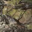
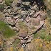
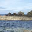
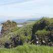
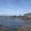
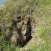
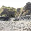
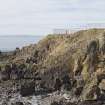
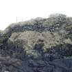
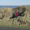
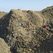
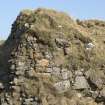
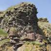
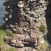
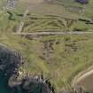
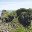
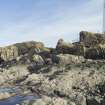
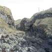
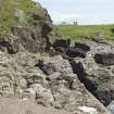
Bruce's Castle, Turnberry, was evidently built in the 13th century with a great enclosing wall, much of which still remained in the 18th century, together with part of what seems to have been a central keep and traces of a drawbridge. Only the ruins of some vaults and portions of wall are now traceable. The keep appears to have been partly circular and the base of an entrance gateway may be traced on the landward side. The castle occupies a strong situation on a rocky promontory; two inlets appear to have been arched over by the wall; at their head there seems to have been a wall with a door and staircase, giving access to the castle. In 1271, the castle was owned by the father of Robert the Bruce.
D MacGibbon and T Ross 1889.
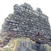
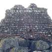
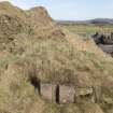
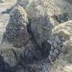
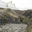
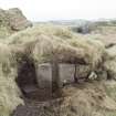
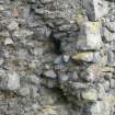
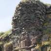
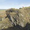
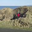
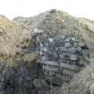
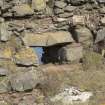
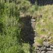
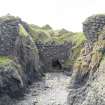
The remains of Turnberry Castle are numerous but fragmentary. The enclosing wall has been built on and around the faces of the cliffs, following the many small bays on the N. On the NE side, where the keep formerly stood, a wall has been built across the back of a small bay with an entrance leading from the bay; at the E side of this wall are the remains of a section of vaulting. Slightly N of this wall are two similar walls built at the rear of two similar coves, one of which extends through a large, natural cavern, Only one wall, on the NE side of the keep, some 5.0m high, remains.
The drawbridge apparently lay at the SE corner, where the present road leads to the lighthouse.
The remains of a ditch lie on either side of the road, outside the wall.
Visited by OS (JD), 1 December 1955.
Turnberry Castle is generally as described in the previous field report.
Revised at 25".
Visited by OS (RD), 16 March 1967.
No change to the previous reports.
Visited by OS (JRL), 31 May 1977.
Based on charter evidence, Barrow indicates that there was a castle at Turnberry prior to 1200.
G W S Barrow 1980.
Online Gallery (1306 - 1329)
The year 2014 sees the 700th anniversary of the Battle of Bannockburn, in which the army of Robert I of Scotland defeated that of Edward II of England. The battle marked a major turning point in the long, drawn-out struggle of the Wars of Independence.
The Wars have had a lasting influence upon all the nations of the United Kingdom and upon the national story. Each age has seen fit to commemorate the events in its own way: through the perpetuation of the genuine historical associations of buildings and places and also through the endowment of others with improbable or fanciful traditions. Where past generations allowed its historic buildings to decay and disappear, later generations began to value and actively preserve these for their associations. Where an event lacked a tangible reminder, as at Kinghorn where Alexander III was killed in a riding accident, a commemorative monument would be erected to act as a focus. The Wars of Independence predate the fashion for accurate portraiture: the weathered, generic military effigy of Sir James Douglas is one of the few to survive in Scotland. Later centuries saw a need and supplied it by a crowd of images of its historic heroes, William Wallace and Robert the Bruce, each depicted according to contemporary taste and imagination. The opening of the new heritage centre at Bannockburn takes this into a new dimension, through the use of three-dimensional, digital technology.
RCAHMS Collections hold many images of these buildings and locations from battlefields, castles and churches, to the many commemorative monuments erected in later years. This gallery highlights a selection of these, including antiquarian sketches, photographic and drawn surveys, and architectural designs.
Field Visit (April 1982)
Turnberry Castle NS 196 072 NS10NE 1
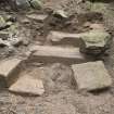
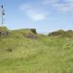
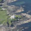
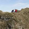
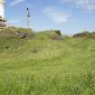
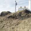
A ruinous curtain-wall encloses an indented coastal promontory now partly occupied by Turnberry Lighthouse. The promontory is flanked by cliffs on the seaward side, where entry to the castle was gained through an impressive sea-gate, and the landward approach was barred by a broad ditch; the site of the landward gate is indicated by part of a portcullis groove in the curtain-wall on the N side of the modern access road to the lighthouse. On the highest point of the promontory, 20m NE of the landward gate, there are the remains of a D-shaped tower. The castle is on record in the 13th century.
RCAHMS 1983, visited April 1982
(Grose 1789-91, ii, 208-9; Paterson 1863-6, ii, 289-91; MacGibbon and Ross 1887-1902, iii, 110-11; Bryden 1910).
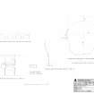
Measured Survey (April 2014)
RCAHMS surveyed Turnberry Castle in April 2014 producing a series of details:
A. Reconstructed profile of Sea-Arch at scale 1:20
B. Plan of Sea-Cave entrance at scale 1:20
C. Profile of Portcullis slot at scale 1:20
D. Profile of South wall of Great Hall at scale 1:20
E. Projected Sea-Arch profile on North elevation at scale 1:50.
The details at A, B, C, D and E are marked on the upper (collection item: DC 62075) and lower (collection item: DC 62076) floor plans.
Archaeological Evaluation (2 December 2014 - 25 May 2016)
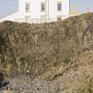
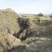
NS 1962 0721 Archaeological works were undertaken at Turnberry Golf Course, between 2 December 2014 and 25 May 2016. Phase 1 comprised a walkover survey and evaluation centred around Turnberry Castle (Canmore ID: 40581), Turnberry Lighthouse and Keeper’s Houses and the adjacent Walled Garden (Canmore ID: 40584). Phases 2 to 5 related to locating and excavating historical service trenches leading towards the castle and lighthouse along with various watching briefs conducted during the installation of the 9th green and the removal of the walled garden. An evaluation and watching brief undertaken during the installation of stairs and paving on the lighthouse’s western terrace included the re-excavation of a trench originally investigated in 2008.
Potentially significant archaeological remains of indeterminate date were uncovered just to the S of the walled garden while a possible entrance to the castle was recorded beneath the current trackway. Two intercutting ditches were excavated within the trench on the western terrace, however, it remains unclear whether they relate to the lighthouse or castle. Many modern services were located within the confines of the castle wall.
Archive: NRHE (intended)
Funder: SLC Turnberry Ltd
Steven Black – Clyde Archaeology
(Source: DES Volume 21)
Measured Survey (December 2014)
RCAHMS surveyed Turnberry Castle in December 2014 producing two cross sections showing corbelling area within the sea-cave, and a plan view looking from the sea-cave floor up into the corbelling showing the location of corbelled stones, at a scale of 1:100.
Project (24 February 2014 - 23 June 2015)
This survey was carried out between 2014 and 2015 by RCAHMS as a Special Survey. It was selected for survey because of the poor quality of the existing record, and has benefited from the Arts and Humanities Research Council Collaborative Doctoral Award to William Wyeth to study Early Stone Castles, 1050-1350 under the supervision of Professor Richard Oram of Stirling University and Dr Piers Dixon, RCAHMS. The survey team from RCAHMS included Heather Stoddart, Iain Anderson, John Borland, Georgina Brown, William Wyeth and Steve Wallace.
Measured Survey (March 2014)
RCAHMS surveyed Turnberry Castle in March 2014 with plane-table and alidade producing a lower plan of the castle at a scale of 1:250. A phased version of the plan was created in vector graphics software.
Measured Survey (March 2014)
RCAHMS surveyed Turnberry Castle in March 2014 with plane-table and alidade producing an upper floor plan of the castle at a scale of 1:250. A phased version of the plan was created in vector graphics software.
Laser Scanning (7 May 2014 - 17 June 2014)
A laser scan survey of parts of Turnberry Castle was carried out in 2014

