 |
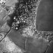
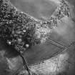
On-line Digital Images |
SC 1724013 |
RCAHMS Aerial Photography |
Oblique aerial view. |
1993 |
Item Level |
|
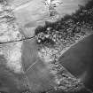 |
On-line Digital Images |
SC 1724014 |
RCAHMS Aerial Photography |
General oblique aerial view, taken from the NW. |
1993 |
Item Level |
|
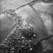 |
On-line Digital Images |
SC 1724015 |
RCAHMS Aerial Photography |
Oblique aerial view. |
1993 |
Item Level |
|
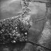 |
On-line Digital Images |
SC 1724016 |
RCAHMS Aerial Photography |
General oblique aerial view centred on teh enclosure, taken from the E. |
1993 |
Item Level |
|
 |
On-line Digital Images |
SC 1724017 |
RCAHMS Aerial Photography |
Oblique aerial view. |
1993 |
Item Level |
|
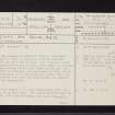 |
On-line Digital Images |
SC 2420480 |
Records of the Ordnance Survey, Southampton, Hampshire, England |
Bute, Craigandun, NS06SE 20, Ordnance Survey index card, page number 1, Recto |
c. 1958 |
Item Level |
|
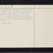 |
On-line Digital Images |
SC 2420481 |
Records of the Ordnance Survey, Southampton, Hampshire, England |
Bute, Craigandun, NS06SE 20, Ordnance Survey index card, page number 2, Verso |
c. 1958 |
Item Level |
|
 |
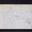
On-line Digital Images |
SC 2420482 |
Records of the Ordnance Survey, Southampton, Hampshire, England |
Bute, Craigandun, NS06SE 20, Ordnance Survey index card, Recto |
c. 1958 |
Item Level |
|
 |
On-line Digital Images |
SC 2420483 |
Records of the Ordnance Survey, Southampton, Hampshire, England |
Bute, Craigandun, NS06SE 20, Ordnance Survey index card, Recto |
c. 1958 |
Item Level |
|
|
All Other |
551 166/1/1 |
Records of the Ordnance Survey, Southampton, Hampshire, England |
Archaeological site card index ('495' cards) |
1947 |
Sub-Group Level |
|


