 |
On-line Digital Images |
DP 106390 |
Scotland's Rural Past |
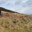
N Sannox W end showing terrace Photo 1 on plan |
19/3/2008 |
Item Level |
|
 |
On-line Digital Images |
SC 1401752 |
General Collection. Glass Lantern Slides |
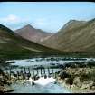
49. Glen Sannox,
Glasgow and "Doon the watter" |
|
Item Level |
|
 |
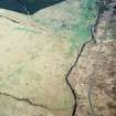
On-line Digital Images |
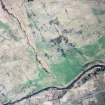
SC 1724038 |
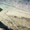
RCAHMS Aerial Photography |
Oblique aerial view centred on the remains of the fort with the remains of the township and field-system adjacent, taken from the N. |
12/5/2005 |
Item Level |
|
 |
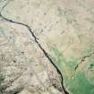
On-line Digital Images |
SC 1724039 |
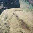
RCAHMS Aerial Photography |
Oblique aerial view centred on the remains of the fort with the remains of the township and field-system adjacent, taken from the WNW. |
12/5/2005 |
Item Level |
|
 |
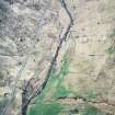
On-line Digital Images |
SC 1724040 |
RCAHMS Aerial Photography |
Oblique aerial view centred on the remains of the township, field-system and rig, taken from the W. |
12/5/2005 |
Item Level |
|
 |
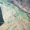
On-line Digital Images |
SC 1724041 |
RCAHMS Aerial Photography |
Oblique aerial view centred on the remains of the township, field-system and rig, taken from the SE. |
12/5/2005 |
Item Level |
|
 |
On-line Digital Images |
SC 1724042 |
RCAHMS Aerial Photography |
Oblique aerial view centred on the remains of the township, field-system and rig, taken from the E. |
12/5/2005 |
Item Level |
|
 |
On-line Digital Images |
SC 1724043 |
RCAHMS Aerial Photography |
Oblique aerial view centred on the remains of the township, field-system and rig, taken from the NW. |
12/5/2005 |
Item Level |
|
 |
On-line Digital Images |
SC 1724044 |
RCAHMS Aerial Photography |
Oblique aerial view centred on the remains of the township, field-system and rig, taken from the SW. |
12/5/2005 |
Item Level |
|
 |
On-line Digital Images |
SC 2420080 |
Records of the Ordnance Survey, Southampton, Hampshire, England |
Arran, North Glen Sannox, NS04NW 17, Ordnance Survey index card, Recto |
c. 1958 |
Item Level |
|
 |
On-line Digital Images |
SC 2420081 |
Records of the Ordnance Survey, Southampton, Hampshire, England |
Arran, North Glen Sannox, NS04NW 17, Ordnance Survey index card, Recto |
c. 1958 |
Item Level |
|
|
All Other |
551 166/1/1 |
Records of the Ordnance Survey, Southampton, Hampshire, England |
Archaeological site card index ('495' cards) |
1947 |
Sub-Group Level |
|


