
Pricing Change
New pricing for orders of material from this site will come into place shortly. Charges for supply of digital images, digitisation on demand, prints and licensing will be altered.
Upcoming Maintenance
Please be advised that this website will undergo scheduled maintenance on the following dates:
Thursday, 9 January: 11:00 AM - 3:00 PM
Thursday, 23 January: 11:00 AM - 3:00 PM
Thursday, 30 January: 11:00 AM - 3:00 PM
During these times, some functionality such as image purchasing may be temporarily unavailable. We apologise for any inconvenience this may cause.
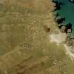
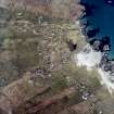
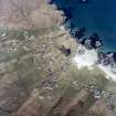
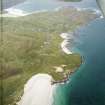
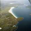
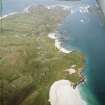
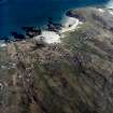
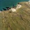
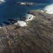
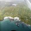
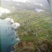
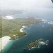
Lewis, Valtos


Field System (Post Medieval), Head Dyke (Post Medieval), Schoolhouse (19th Century), Township (Post Medieval)
Site Name Lewis, Valtos
Classification Field System (Post Medieval), Head Dyke (Post Medieval), Schoolhouse (19th Century), Township (Post Medieval)
Alternative Name(s) Bhaltos
Canmore ID 4010
Site Number NB03NE 18
NGR NB 0930 3680
NGR Description Centred on NB 0930 3680
Datum OSGB36 - NGR
Permalink http://canmore.org.uk/site/4010


- Council Western Isles
- Parish Uig
- Former Region Western Isles Islands Area
- Former District Western Isles
- Former County Ross And Cromarty
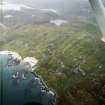
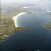
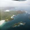
Cliff, Valtos (Bhaltos), Kneep (Cnip), Reef Ring of traditional crofting and fishing settlements on a wing-shaped peninsula rich in archaeological remains. These include the causewayed islet Dun Baravat, a complex roundhouse on a hill loch; the excellently preserved lower part of a broch tower on Loch na Berie, overbuilt with later cellular structures until c.9th century AD; five 19th century grain mills, above the road at Traigh na Berie, and an Iron Age wheelhouse complex at kneep.
Taken from "Western Seaboard: An Illustrated Architectural Guide", by Mary Miers, 2008. Published by the Rutland Press http://www.rias.org.uk

NB03NE 18 centred on 0930 3680
NB03NE 18.01 0952 3692 Fish Curing Building
A township, comprising thirty-seven roofed buildings, of which twelve are annotated as ruin, one partially roofed building, six unroofed buildings, some enclosures, a field-system and a head-dyke is depicted on the 1st edition of the OS 6-inch map (Island of Lewis, Ross-shire 1854, sheet 17). To the N there are further lengths of head-dyke which may be associated with this site.
A crofting township, comprising forty-six roofed, three partially roofed, sixteen unroofed buildings and a crofting field-system is shown on the current edition of the OS 1:10000 map (1974).
Information from RCAHMS (AKK) 19 September 1997.
Trial Trench
NB 0936 3688 The site of a proposed new house, on the same location as a former building recorded on 1st Edition OS map but now not surviving above ground, was investigated by trial trenching. As the location of the site made the use of a mechanical digger impractical, the trenching was carried out by hand, which greatly increased the archaeological information recovered. The clay floor and stone-lined drain within the former
building were located, and a rich assemblage of ceramics dating to the early to mid 19th century was recovered from layers immediately overlying the natural gravels. No earlier structure or occupation on the site was identified.
Funder: Mary MacDougall.

