
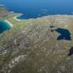
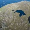
Taransay, Loch An Duin


Crannog (Prehistoric)(Possible), Dun (Prehistoric)
Site Name Taransay, Loch An Duin
Classification Crannog (Prehistoric)(Possible), Dun (Prehistoric)
Canmore ID 3995
Site Number NB00SW 6
NGR NB 02162 01279
Datum OSGB36 - NGR
Permalink http://canmore.org.uk/site/3995


- Council Western Isles
- Parish Harris
- Former Region Western Isles Islands Area
- Former District Western Isles
- Former County Inverness-shire
On an islet (crannog) in Loch an Dùin, a small prehistoric dun with a stone causeway. From linking Loch Shinnadale, Allt a' Mhuilinn flows down through several lochans, with at least three horizontal cornmills along its course - one, Bun na Muilinn, with a wheel.
Taken from "Western Seaboard: An Illustrated Architectural Guide", by Mary Miers, 2008. Published by the Rutland Press http://www.rias.org.uk

NB00SW 6 02162 01279
(NB 0216 0127) Dun (NR)
OS 6" map, Inverness-shire, 2nd ed., (1903)
The remains of a dun occupy an islet connected with the shore of Loch and Duin by a causeway about 35 yards long. The building is D-shaped with walls varying from 4 to 6ft in height, rising abrupt- ly from the water's edge.
Mr Wedderspoon, a member of the Inverness Field Club, (see F O Blundell 1913) who surveyed the building before 1913, considered that the island was artificial and that the building was of much later date.
RCAHMS 1928, visited 17 July 1914; F O Blundell 1913; F W L Thomas 1890.
A D-shaped dun, generally as described and planned by the RCAHMS.
There is no sign of an entrance but it is probably in the NW side, obscured by tumble and vegetation. A short stretch of a medial stabilising wall is visible in the centre of the south end of this same wall.
Visited by OS (A A) 7 July 1969.
Field Visit (17 June 1914)
Dun, Loch an Duin, Taransay.
On an islet some 35 yards from the south-eastern shore of Loch an Duin, a small loch in the hills on the island of Taransay, are the remains of a dun, the wall of which rises abruptly from the water's edge. It is connected with the shore by a causeway 4 feet wide, with a slight curve near the middle. The building is D-shaped on plan, the straight side being towards the northwest, the side away from the shore. The outer face of the wall is still in position for a height of 6 feet to the south-west, 4 feet 6 inches on the south-east and 4 feet to the north-east, but the greater part of the straight north-western side has collapsed. Evidence of an outer casing or possibly gallery wall 3 feet 6 inches thick is seen at the southern extremity of the latter, a structural feature confined to this side. Towards the north-west the inner face of the building shows a height of 3 feet, but on the opposite and curved side it is almost entirely obscured by tumbled stones. The wall varies from 8 ½ feet to 10 feet in width, and the interior of the dun is 20 feet from north-east-to south-west and 16 feet across. At the west end of the north-east wall is a recess 5 ½ feet long by 1 ½ feet deep. The entrance is not distinguishable, but has probably been towards the east. (Fig. 99.)
RCAHMS 1928, visited 17 July 1914.
OS map: Harris xii.
Measured Survey (28 July 1923)
RCAHMS surveyed this site by plane-table on 28 July 1923. The resultant plan was redrawn in ink and published at a reduced size in RCAHMS 1928 as Figure 91.

