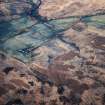
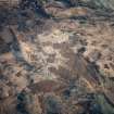
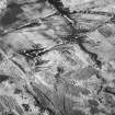
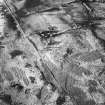
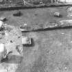
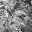
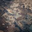
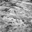
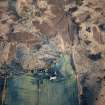
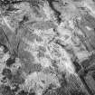
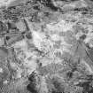
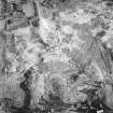
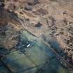
Accessibility

Font Size

100% 150% 200%

Background Colour

Default Contrast
Close Reset

Arran, Machrie Moor

Stone Circle(S) (Neolithic) - (Bronze Age)

Site Name Arran, Machrie Moor

Classification Stone Circle(S) (Neolithic) - (Bronze Age)

Canmore ID 39699

Site Number NR93SW 1

NGR NR 90876 32351

NGR Description centred on NR 90876 32351

Datum OSGB36 - NGR

Permalink http://canmore.org.uk/site/39699

Ordnance Survey licence number AC0000807262. All rights reserved.
Canmore Disclaimer. © Bluesky International Limited 2025. Public Sector Viewing Terms

Toggle Aerial | View on large map

Digital Images

Machrie Moor, oblique aerial view, centred on a group of stone circles.
Machrie Moor, oblique aerial view, centred on a group of stone circles.Machrie Moor, oblique aerial view.Machrie Moor, oblique aerial view, centred on three stone circles.Machrie Moor, oblique aerial view, centred on stone circle 5.Machrie Moor, oblique aerial view, centred on two stone circles.Machrie Moor, oblique aerial view.Aerial photograph from S.Excavation photograph. Shots from tower to east of site showing newly opened area. Sites 4 and 5.Excavation photograph. Shots from tower to east of site showing newly opened area. Sites 4 and 5.Excavation photograph. Shots from tower to east of site showing newly opened area. Sites 4 and 5.Machrie Moor and Moss Farm, oblique aerial view, centred on stone circle 5.Aerial photograph from SW.Aerial photograph from N.Aerial photograph.Aerial photograph from NW.Machrie Moor, oblique aerial view, centred on three stone circles.Machrie Moor and Moss Farm, oblique aerial view, with the stone circles in the top half of the photograph and a hut-circle and possible hut-circle in the bottom half.Aerial photograph from SE.Aerial photograph from W.Machrie Moor, oblique aerial view, centred on stone circle 5.Machrie Moor and Moss Farm, oblique aerial view, with three stone circles in the top half of the photograph and a hut-circle and possible hut-circle in the bottom half.Aerial photograph from NE.Excavation photograph. Shots from tower to east of site showing newly opened area. Sites 4 and 5.Machrie Moor, oblique aerial view, centred on two stone circles.Machrie Moor, oblique aerial view, centred on two stone circles.Machrie Moor, oblique aerial view, centred on three stone circles.Aerial photograph from W.Arran, Machrie Moor, NR93SW 1, Ordnance Survey index card, page number 1, RectoCircle 4 looking south east. Machrie Moor, oblique aerial view, centred on two stone circles.Excavation photograph. Shots from tower to east of site showing newly opened area. Sites 4 and 5.Arran, Machrie Moor, NR93SW 1, Ordnance Survey index card, RectoMachrie Moor, oblique aerial view, centred on three stone circles.Aerial photograph from N.Aerial photograph from E.Excavation photograph. Shots from tower to east of site showing newly opened area. Sites 4 and 5.Excavation photograph. Shots from tower to east of site showing newly opened area. Sites 4 and 5.Machrie Moor, oblique aerial view, centred on stone circle 5.Aerial photograph, from W.Aerial photograph.Aerial photograph from NW.Excavation photograph. Shots from tower to east of site showing newly opened area. Sites 4 and 5.

Administrative Areas

  • Council North Ayrshire
  • Parish Kilmory
  • Former Region Strathclyde
  • Former District Cunninghame
  • Former County Buteshire

Archaeology Notes

NR93SW 1.00 centred on 90876 32351

See also NR93SW 3, NR93SW 10, NR93SW 11.

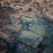
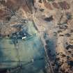
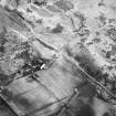
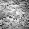
NR93SW 1.01 NR 9101 3245 Stone circle (A: 'Machrie Moor 3')

NR93SW 1.02 NR 9100 3235 Stone circle (B: 'Machrie Moor 4')

NR93SW 1.03 NR 9113 3242 Stone circle (C: 'Machrie Moor 2')

NR93SW 1.04 NR 9120 3239 Stone circle (D: 'Machrie Moor 1')

NR93SW 1.05 NR 9121 3241 Stone circle (E: 'Machrie Moor 3')

(Name: NR 9107 3240) Stone Circles (NR).

OS 6" map (1924)

Five 'Stone Circles', A : at NR 9101 3245, B : at NR 9100 3235; C : at NR 9113 3242, D : at NR 9120 3239, and E : at NR 9121 3241 are shown on OS 6". They are described individually under NR93SW 1.01 to 1.05 respectively.

Information from OS Recorder (IF) 22 February 1973

Discussion on these 'Stone Circles'.

H A W Burl 1976

Activities

Aerial Photography (13 December 1996)

References

MyCanmore Image Contributions


Contribute an Image

MyCanmore Text Contributions