
Pricing Change
New pricing for orders of material from this site will come into place shortly. Charges for supply of digital images, digitisation on demand, prints and licensing will be altered.
Auchoish


Chambered Cairn (Neolithic)
Site Name Auchoish
Classification Chambered Cairn (Neolithic)
Canmore ID 39561
Site Number NR89SE 8
NGR NR 8704 9111
Datum OSGB36 - NGR
Permalink http://canmore.org.uk/site/39561


- Council Argyll And Bute
- Parish Kilmichael Glassary
- Former Region Strathclyde
- Former District Argyll And Bute
- Former County Argyll
NR89SE 8 8704 9111.
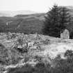
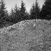
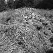
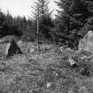
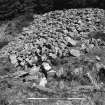
A long horned cairn, its facade facing NNE, which was excavated by Craw in 1931.
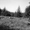
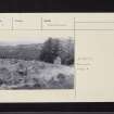
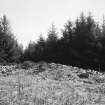
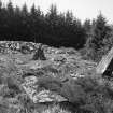
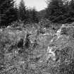
It has been severely disturbed, especially at the N end, but it has probably measured between 130' and 135' long, probably about 45' across the N end, where it is now 50' across, and 15' across the S end. The robbing of the N end is so extensive that the present cairn edge bears little relation to the original form of the end of the cairn though the remaining orthostats indicate that there has been a chamber, forecourt, and horns. Behind the main chamber the cairn still stands 5' high and it drops gently to about 2' at the S end, though its profile is interrupt- ed by robbing across the cairn to expose the burial chamber. The cairn edges and the S end are overgrown by grass and bracken, but along the centre it remains free of vegetation. The area is now part of an extensive Forestry Commission forest.
The cairn has been robbed to provide material for enclosures to the S and a rectangular structure to the E, which measures 18' x 12 1/2' internally and in which Craw picked up a flint knife in a molehill.
A S Henshall 1972; J H Craw 1932; M Campbell and M Sandeman 1964
A chambered cairn, generally as described and planned.
Surveyed at 1:10,000.
Visited by OS (DWR) 7 May 1973
NR 8704 9112. No change to the previous information.
Surveyed at 1/10,000.
Visited by OS (BS) 28 March 1977
Field Visit (June 1981)
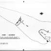
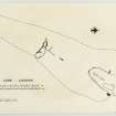
This chambered cairn is situated 900 m NE of Auchoish, on the SE side of the valley of the Auchoish Burn (Campbell and Sandeman 1964, no.40). Excavations were carried out on the site in 1931, and the present account incorporates information from the published report (Craw 1932, 445-7).
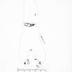
Lying at a slight angle to the contour, the cairn is about 40m long with a deep concave forecourt at the upper (NNE) end, where it is 15m broad and up to 1.6m high; it tapers to a width of 3.5m and a height of 0.6m at the SSW end. On the uphill side the cairn material probably retains its original outline, but it has been spread on the lower side (Henshall 1972, 332-3).
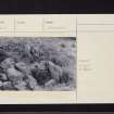
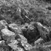
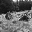
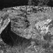
The forecourt, which measured about 8m in breadth across the horns and about 2.6m in depth, has been severely disturbed by stone-robbing. Of the spaced orthostats which appear to have formed its facade, only three stones have survived in position; three more which have probably been dislodged from the facade can be seen lying in the forecourt itself. About 5.3m SSW of the estimated line of the facade the back slab of the main chamber can be seen protruding 1m above present ground level; excavation revealed that the full height of this stone was about twice as much.
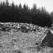
About 20m SSW of the forecourt there is a curving lateral chamber, aligned roughly WNW and ESE, and entered from the ESE side of the cairn. It is about 5.5m long and divided into three compartments, which decrease in width from 1m at the entrance to 0.4m at the inner end. The walls are formed by a series of slabs standing up to 0.7m in height, and three small slabs were found to have been set on edge as a kerb across the entrance to the chamber, but only one of them is now visible.
Of the two stones that divided the outer and central compartments, only that on the S side survives; it projects 0.4 m from the side of the chamber and appears to have been deliberately shaped to form one part of a 'porthole' opening. The septal slab between the central and inner compartments is 0.8m wide, and the inner end of the third compartment is formed by two slabs set one behind the other. The more easterly of these is similarly shaped to that between the outer and central compartments, but could not have formed part of a 'porthole' arrangement in its present position. The side-slabs of the inner compartment project beyond the present end of the chamber, and, after a gap of 0.3m, another slab continues the line of the SSW wall for a distance of 0.9m beyond the chamber; it is possible that this represents part of a fourth compartment.
In addition to the features that are visible at present, the excavation revealed a setting of boulders and slabs to the NE of the chamber running for a distance of some 5.5m along the main axis of the cairn. It was suggested that these might be the remains of a chamber and a passage. No finds were made during the excavation, but a flint knife was found a little to the S of the cairn.
Visited June 1981
RCAHMS 1988
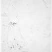
Measured Survey (17 June 1981)
RCAHMS surveyed Auchoish chambered cairn on 17 June 1981 with plane-table and alidade producing a plan at a scale of 1:100. The plan of the cairn was redrawn in ink and published at a scale of 1:250 (RCAHMS 1988a, 41).

