
Kilmartin


Village (Period Unassigned)
Site Name Kilmartin
Classification Village (Period Unassigned)
Canmore ID 39533
Site Number NR89NW 86
NGR NR 8350 9890
NGR Description Centred NR 8350 9890
Datum OSGB36 - NGR
Permalink http://canmore.org.uk/site/39533
Ordnance Survey licence number AC0000807262. All rights reserved.
Canmore Disclaimer.
© Bluesky International Limited 2025. Public Sector Viewing Terms
- Correction
- Favourite

DP 259605
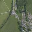
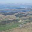
Oblique aerial view.
Historic Environment Scotland
20/6/2017
© Crown Copyright: HES

SC 1831809
Kilmartin Village, Argyll and Bute district
Scottish Development Department
© Crown Copyright: HES (Scottish Development Department)

SC 1831811
Kilmartin Village, Argyll and Bute district
Scottish Development Department
© Crown Copyright: HES (Scottish Development Department)

SC 1831814
Kilmartin Village, Argyll and Bute district
Scottish Development Department
© Crown Copyright: HES (Scottish Development Department)

SC 1831824
Kilmartin Village, Argyll and Bute district
Scottish Development Department
© Crown Copyright: HES (Scottish Development Department)

SC 2418352
Kilmartin, NR89NW 86, Ordnance Survey index card, Recto
Records of the Ordnance Survey, Southampton, Hampshire, England
c. 1958
© Crown Copyright: HES (Ordnance Survey Archaeology Division)

DP 017899
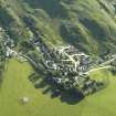
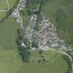
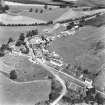
General oblique aerial view of the village, centred on the church, churchyard, burial ground, museum and the remains of the cairn with the tower-house adjacent, taken from the SW.
RCAHMS Aerial Photography Digital
27/6/2006
© Crown Copyright: HES

DP 252935
Oblique aerial view.
Historic Environment Scotland
3/5/2017
© Copyright: HES

SC 1683322
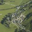
Kilmartin, Kilmartin Church, Churchyard and Village. Oblique aerial view from South-West.
RCAHMS Aerial Photography
1984
© Crown Copyright: HES

SC 1831808
Kilmartin Village, Argyll and Bute district
Scottish Development Department
© Crown Copyright: HES (Scottish Development Department)

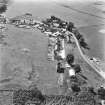
SC 724641
Kilmartin, general. General view from South. Titled: 'Kilmartin from South'.
Collection of photographs and postcards by J Valentine and Sons Ltd, photographers, Dundee, Scotland
c. 1930
© Courtesy of HES (J Valentine and Sons)

DP 017900
General oblique aerial view of the village, centred on the church, churchyard, burial ground, museum and the remains of the cairn with the tower-house adjacent, taken from the SSW.
RCAHMS Aerial Photography Digital
27/6/2006
© Crown Copyright: HES

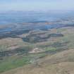
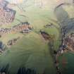
SC 1201844
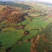
General oblique view of the valley showing the remains of the standing stones and cairns at Kilmartin, and the school and farmstead, taken from the SE.
RCAHMS Aerial Photography
22/11/2001
© Crown Copyright: HES

DP 157320
View of various figures surrounding a horse-drawn coach, supposodly from 'Ardrishaig, all situated outside Kilmartin Inn, now known as 'Kilmartin Hotel', Kilmartin, Argyll. PHOTOGRAPH ALBUM No. 187, (cf PAs 186 and 188) Rev. J.B. MacKenzie of Colonsay Albums,1870, vol.2.
General Collection. Photograph Albums.
c. 1861
© Courtesy of HES (Photographs by Rev James Bannatyne Mackenzie)

DP 259592
Oblique aerial view.
Historic Environment Scotland
20/6/2017
© Crown Copyright: HES

SC 1831815
Kilmartin Village, Argyll and Bute district
Scottish Development Department
© Crown Copyright: HES (Scottish Development Department)

SC 1831822
Kilmartin Village, Argyll and Bute district
Scottish Development Department
© Crown Copyright: HES (Scottish Development Department)

SC 2525375
Kilmartin, Kilmartin Church & Churchyard. General view from South-West.
1984
© RCAHMS

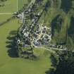
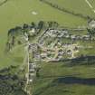
DP 017901
General oblique aerial view of the village, centred on the church, churchyard, burial ground, museum and the remains of the cairn with the tower-house adjacent, taken from the SE.
RCAHMS Aerial Photography Digital
27/6/2006
© Crown Copyright: HES

DP 017902
General oblique aerial view of the village, centred on the church, churchyard, burial ground and museum with the tower-house and quarry adjacent, taken from the SE.
RCAHMS Aerial Photography Digital
27/6/2006
© Crown Copyright: HES

SC 1683317
Kilmartin, Kilmartin Church, Churchyard and Village. Oblique aerial view from South.
RCAHMS Aerial Photography
1984
© Crown Copyright: HES

SC 1831818
Kilmartin Village, Argyll and Bute district
Scottish Development Department
© Crown Copyright: HES (Scottish Development Department)


SC 1683248
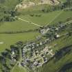
Kilmartin & Kilmartin Castle. Oblique aerial view from South-East.
RCAHMS Aerial Photography
1977
© Crown Copyright: HES

SC 1683250
Kilmartin, Kilmartin Parish Church, Churchyard and Village. Oblique aerial view from South.
RCAHMS Aerial Photography
1977
© Crown Copyright: HES

SC 1683318
Kilmartin, Kilmartin Church, Churchyard and Village. Oblique aerial view from South.
RCAHMS Aerial Photography
1984
© Crown Copyright: HES

SC 1831810
Kilmartin Village, Argyll and Bute district
Scottish Development Department
© Crown Copyright: HES (Scottish Development Department)

SC 1831819
Kilmartin Village, Argyll and Bute district
Scottish Development Department
© Crown Copyright: HES (Scottish Development Department)

SC 1831820
Kilmartin Village, Argyll and Bute district
Scottish Development Department
© Crown Copyright: HES (Scottish Development Department)

DP 259588
Oblique aerial view.
Historic Environment Scotland
20/6/2017
© Crown Copyright: HES

DP 259598
Oblique aerial view.
Historic Environment Scotland
20/6/2017
© Crown Copyright: HES

SC 1683249
Kilmartin, Kilmartin Parish Church, Churchyard and Village. Oblique aerial view from South-West.
RCAHMS Aerial Photography
1977
© Crown Copyright: HES

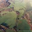
SC 1723788
General oblique view of the valley showing the remains of the standing stones and cairns, and the school and farmstead, taken from the SW.
RCAHMS Aerial Photography
22/11/2001
© Crown Copyright: HES

SC 1723789
General oblique view of the valley showing the remains of the standing stones and cairns, and the school and farmstead, taken from the SSW.
RCAHMS Aerial Photography
22/11/2001
© Crown Copyright: HES

SC 1831817
Kilmartin Village, Argyll and Bute district
Scottish Development Department
© Crown Copyright: HES (Scottish Development Department)

SC 2418351
Kilmartin, NR89NW 86, Ordnance Survey index card, Recto
Records of the Ordnance Survey, Southampton, Hampshire, England
c. 1958
© Crown Copyright: HES (Ordnance Survey Archaeology Division)

SC 2525371
Kilmartin, Kilmartin Church & Churchyard. General view from South.
1984
© RCAHMS


DP 017903
General oblique aerial view of the village, centred on the church, churchyard, burial ground, museum and the remains of the cairn, taken from the ESE.
RCAHMS Aerial Photography Digital
27/6/2006
© Crown Copyright: HES


DP 252934
Oblique aerial view.
Historic Environment Scotland
3/5/2017
© Copyright: HES

SC 1831813
Kilmartin Village, Argyll and Bute district
Scottish Development Department
© Crown Copyright: HES (Scottish Development Department)

SC 1831816
Kilmartin Village, Argyll and Bute district
Scottish Development Department
© Crown Copyright: HES (Scottish Development Department)


SC 1683247
Kilmartin & Kilmartin Castle. Oblique aerial view from North.
RCAHMS Aerial Photography
1977
© Crown Copyright: HES

SC 1683319
Kilmartin, Kilmartin Church, Churchyard and Village. Oblique aerial view from East.
RCAHMS Aerial Photography
1984
© Crown Copyright: HES

SC 1831812
Kilmartin Village, Argyll and Bute district
Scottish Development Department
© Crown Copyright: HES (Scottish Development Department)

SC 1831821
Kilmartin Village, Argyll and Bute district
Scottish Development Department
© Crown Copyright: HES (Scottish Development Department)

SC 1831823
Kilmartin Village, Argyll and Bute district
Scottish Development Department
© Crown Copyright: HES (Scottish Development Department)

SC 2525370
Kilmartin, Kilmartin Church & Churchyard. General view from South.
1984
© RCAHMS


- Council Argyll And Bute
- Parish Kilmartin
- Former Region Strathclyde
- Former District Argyll And Bute
- Former County Argyll
NR89NW 86 centred 8350 9890

