
Baroile


Chambered Cairn (Neolithic)
Site Name Baroile
Classification Chambered Cairn (Neolithic)
Canmore ID 39467
Site Number NR89NW 26
NGR NR 8476 9548
Datum OSGB36 - NGR
Permalink http://canmore.org.uk/site/39467


- Council Argyll And Bute
- Parish Kilmichael Glassary
- Former Region Strathclyde
- Former District Argyll And Bute
- Former County Argyll
NR89NW 26 8476 9548.
(NR 8476 9548) Cairn (NR) (Cist found) (NAT)
OS 6" map, (1924)
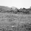
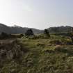
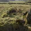
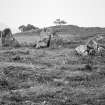
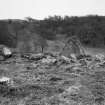
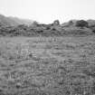
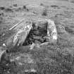
This chambered cairn is situated on a terrace, broken up by mounds of outcrop, and seems to be on one of those knolls. There is now a low mound, covered with grass and bracken, which is delimited by the edge of the ploughing, and on to which some field stones have been cleared. It measures c. 84' N-S by 75'. The size of the cairn itself may actually be less, but its edge cannot be differentiated from the knoll. There is probably about 2' of cairn material remaining, but on the N side the rise from the field is c. 5', presumably natural.
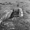
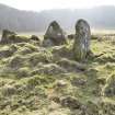
Four stones of an irregular facade, 22'6" across, facing NNE, remain, set 30' inside the apparent edge of the cairn. The entry between the portal stones is 13" wide. There has been a double portal, for there is a second stone, 2'8" high, immediately behind the W portal stone; there is no sign of the corresponding stone on the E. The chamber has two compartments aligned on slightly different axes. Of the other compartment, the NW side stone is missing, but the NE stone remains, 8' long, 1'6" above ground level. The inner compartment is cleared out to a lower level, the side stones exposed to a height of 3'2", and the low back-slab to 1'9". The septal stone, 2'10" long, is c. 1'6" lower than the side stones. 41' N of the westernmost facade, and 17' from the apparent edge of the cairn, there lies a flat slab partly buried, 6' x 3'6". About 14' beyond it, there is another, c. 4' x 2'6".
Excavations were carried out on this cairn by Craw in 1929, but no artifacts were found (Craw 1930).
A S Henshall 1972; J H Craw 1930; M Campbell and M Sandeman 1964.
NR 8478 9548. As described.
Resurveyed at 1:2500.
Visited by OS (I A) 3 May 1973.
NR 8477 9549. A chambered cairn as planned and described in the previous information. The two slabs noted by Henshall are well beyond the extent of the cairn; neither appears to have been disturbed and they cannot be identified as cist covers.
Surveyed at 1/10,000.
Visited by OS (B S) 13 April 1977.
Field Visit (May 1982)
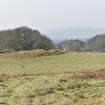
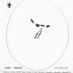
This cairn is situated about 650m ENE of Rhudil Mill on a low knoll in the valley of the Rhudil Burn (Campbell and Sandeman 1964, no. 42; Henshall 1972, 334); the grass-covered cairn, roughly oval on plan, measures about 26m by 24m and stands up to 1m high on the S, with the facade, which faces NNE, lying 10m from its N edge.
Four upright stones and the stump of a fifth make up the facade, which measures 7.5m across. The most easterly stone is 1.1m high, and the E portal stone 0.4 m high. Immediately behind the W portal stone, which is 1.25m high, there is a second stone, 0.8m high, forming one side of a double portal; nothing can be seen of its counterpart on the E side. To the W of the W portal stone, level with the turf, there is the stump of a slab 0.9m long and about 0.lm thick. The most westerly facade stone stands 1.55m in height.
Entered through the gap between the portal stones, the chamber measures about 3.5m in length by 0.8m in breadth and up to 0.85m in height internally. It is divided into two compartments aligned on slightly differing axes by a septal stone 0.5m high, and there is a firmly set transverse slab (0.3m long by 0.1m thick and barely visible above the turf), situated 0.7m to the N. The W side of the outer compartment is missing, but the E side-slab is exposed to a height of 0.5m, overlapping the stone immediately to the S of it. This stone forms the E side of the inner compartment, which measures 1.85m by 0.85m internally. The back-slab, which is lower than the side-slabs, is exposed to a height of 0.55m. Excavations carried out in 1929 produced no finds (Craw 1930, 139-40).
To the NNW of the cairn two large dislodged slabs lie partly buried.
Visited May 1982
RCAHMS 1988
Measured Survey (4 May 1982)
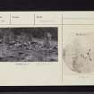
RCAHMS surveyed Baroile chambered cairn on 04 May 1982 with plane-table and alidade producing a plan at a scale of 1:100. The plan of the cairn was redrawn in ink and published at a scale of 1:250 (RCAHMS 1988a, 43).

