
Arran, Torbeg


Cairnfield (Period Unassigned), Field System (Period Unassigned), Hut Circle (Prehistoric)
Site Name Arran, Torbeg
Classification Cairnfield (Period Unassigned), Field System (Period Unassigned), Hut Circle (Prehistoric)
Canmore ID 39204
Site Number NR82NE 4
NGR NR 8917 2999
Datum OSGB36 - NGR
Permalink http://canmore.org.uk/site/39204


- Council North Ayrshire
- Parish Kilmory
- Former Region Strathclyde
- Former District Cunninghame
- Former County Buteshire
NR82NE 4 8917 2999.
(NR 8916 2999) Hut Circle (NR)
OS 6" map, Buteshire, 2nd ed., (1924)
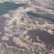
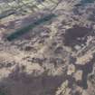
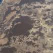
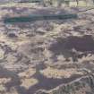
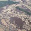
NR 8917 2999 a heather-covered hut circle situated on gently sloping moorland at 250ft OD. The earth and stone bank, spread to 2.5m and 0.8m high, encloses a level interior 9.0m in diameter. There is a 1.5m wide entrance in the south east,fronted at a distance of 3.0m by a crescentic earth and stone bank 6.0m long.
Surveyed at 1:2500
A sinuous earth and stone bank, 2.5m wide and 0.6m high, skirts the hut at a distance of 2.0m on the west side. It runs north-west and south-west for distances of 80.0m and 50.0m respectively before disappearing in the peat. It is almost certainly a comtemporaneous field bank; there is no other evidence of a field system.
To the west of the hut is a group of approximately 15 heather-covered stony mounds similar to other probable clearance heaps in this area. (See NR83SE 11.)
Visited by OS (TRG) 20 October 1977.

