
South Leachnaban


Enclosure (Period Unassigned), Hut Circle (Prehistoric)
Site Name South Leachnaban
Classification Enclosure (Period Unassigned), Hut Circle (Prehistoric)
Canmore ID 39184
Site Number NR79SE 31
NGR NR 7832 9215
Datum OSGB36 - NGR
Permalink http://canmore.org.uk/site/39184


- Council Argyll And Bute
- Parish North Knapdale
- Former Region Strathclyde
- Former District Argyll And Bute
- Former County Argyll
NR79SE 31 783 921.
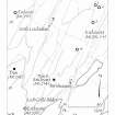
NR 78321 92154 Several upright stones, up to 0.4m high, form an intermittent circle about 9.5m in diameter. The circle is completed by a low, grass covered bank and there are no visible internal features. With a diameter of 9.5m this could be termed a hut circle rather than a homestead. It is located on a slight rise.
Heather F James, 2003 (RCAHMS MS 2371, no.81)
Field Visit (May 1985)
This enclosure, which has been severely disturbed by forestry planting and felling, stands on a level terrace about 400m WNW of South Leachnaban. An area about 10m in diameter has been enclosed by a ruined wall about 1.2m thick, whose surviving traces are a number of inner and outer facing-stones; no core material can, however, now be seen.
RCAHMS 1988, visited by RCAHMS May 1985.
(Kahane 1986)

