
Dun Skeig


Cup Marked Rock (Prehistoric), Dun(S) (Period Unassigned), Fort (Period Unassigned)
Site Name Dun Skeig
Classification Cup Marked Rock (Prehistoric), Dun(S) (Period Unassigned), Fort (Period Unassigned)
Canmore ID 38925
Site Number NR75NE 1
NGR NR 7577 5721
Datum OSGB36 - NGR
Permalink http://canmore.org.uk/site/38925


- Council Argyll And Bute
- Parish Kilcalmonell
- Former Region Strathclyde
- Former District Argyll And Bute
- Former County Argyll
NR75NE 1 7577 5721.
(NR 7574 5717) Fort (NR) (Vitrified)
(NR 7580 5724) Fort (NR)
OS 6" map, (1924)
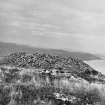
Three successive structures may be distinguished on the summit of Dun Skeig.
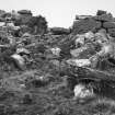
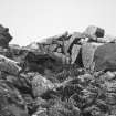
The first (I on plan) is a fort measuring c. 113m by 36.5m within a single stone wall; the second, an oval dun within a vitrified wall (II) which partly overlies the SW end of the fort; and the third, a well-preserved dun (III) whose wall contains pieces of vitrified material presumably taken from the ruins of II.
The fort wall, which originally enclosed the whole of the summit, has been very severly robbed. In the SE it survives as a low stony bank, 3.0m wide, in which one outer facing stone is visible, while further N its course is marked by two separate stretches of outer face. On the SW and W, the wall appears as a mere crest-line, but on the N it is represented by a band of debris from which numerous outer facing stones protrude. This is in such contrast to the other parts of the wall, it may be a later rebuilding of this section as an outwork to the adjacent dun. The principal entrance to the fort was probably to the W of this dun, where the crest line marking the side of the wall is interrupted by a track. No internal buildings were found.
The larger dun (II) consists of an oval enclosure, 26m x 18.5m, within a stone wall, the core of which has been completely vitrified. This now appears as a bank of debris, varying from 2.4m - 6.1m thick. No facing stones are visible, so that the original width of the wall is uncertain. The N half of the interior is ocupied by a scarp 3.4m high, but it is not certain whether this is natural or artificial. The rest of the interior is level and featureless. No entrance is visible.
The smaller dun (III) measures 14.6m x 12.8m within a wall 3.0m - 4.6m thick, standing 1.8m high internally. It has a well-defined entrance in the NE, with door-checks and traces of a bar-hole in the N wall. No other mural features, such as cells or galleries, can be seen. A small area of living rock, bearing 3 plain cup marks, lies c.2.1m outside the wall of II, on its NNE arc.
RCAHMS 1971, visited 1963.
Three structures, as described and planned by RCAHMS, consisting of two duns (one vitrified) enclosed by the remains of an earlier fort. The RCAHMS description of the cup marked rock is also correct.
Surveyed at 1:10,000.
Visited by OS (D W R) 4 July 1973.
No change to report of 4 July 1973.
Surveyed at 1/10,000
Visited by OS (B S) 14 March 1977.
Note (13 October 2014 - 25 November 2016)
This fort is situated on the elongated summit of Dun Skeig, a prominent position overlooking the mouth of West Loch Tarbert from Kintyre, and has an oval dun displaying massive vitrifaction overlying the SW end, and a second dun with its wall substantially intact overlying the other. The fort itself measures about 110m from NE to SW by between 17m and 40m transversely (0.34ha) within a single wall which has been reduced to either a low bank or a scarp everywhere except at the NE end, where long runs of the outer face remain in place. The differential preservation here led RCAHMS investigators to speculate that this end of the fort had been rebuilt as an outwork to the dun crowning this end of the summit. The investigators also observed pieces of vitrified stone incorporated into the wall of the dun, which is thus thought to be more recent than the vitrified dun on the SW end of the summit. The entrance to the fort may have been at the northern end of the NW side, where a trackway traverses the line of the wall, though its axis from N to S does not conform to the possible stagger in the positions of the terminals to either side of the gap.
Information from An Atlas of Hillforts of Great Britain and Ireland – 25 November 2016. Atlas of Hillforts SC2268

