
Pricing Change
New pricing for orders of material from this site will come into place shortly. Charges for supply of digital images, digitisation on demand, prints and licensing will be altered.
Upcoming Maintenance
Please be advised that this website will undergo scheduled maintenance on the following dates:
Thursday, 9 January: 11:00 AM - 3:00 PM
Thursday, 23 January: 11:00 AM - 3:00 PM
Thursday, 30 January: 11:00 AM - 3:00 PM
During these times, some functionality such as image purchasing may be temporarily unavailable. We apologise for any inconvenience this may cause.
Gort Na H-ulaidhe, Glen Lussa


Chambered Cairn (Neolithic)
Site Name Gort Na H-ulaidhe, Glen Lussa
Classification Chambered Cairn (Neolithic)
Alternative Name(s) Arg 30
Canmore ID 38777
Site Number NR72NW 3
NGR NR 74500 26850
Datum OSGB36 - NGR
Permalink http://canmore.org.uk/site/38777


- Council Argyll And Bute
- Parish Campbeltown
- Former Region Strathclyde
- Former District Argyll And Bute
- Former County Argyll
NR72NW 3 74500 26850
(NR 7451 2685) Cairn (NR) (Gort na h-Ulaidhe) (NAT)
OS 6" map, Argyllshire, 2nd ed., (1924)
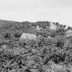
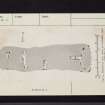
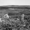
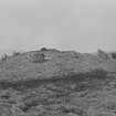
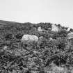
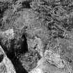
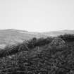
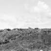
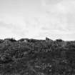
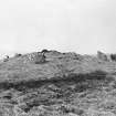
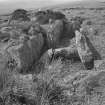
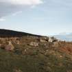
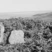
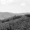
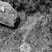
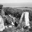
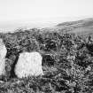
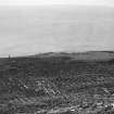
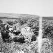
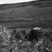
A Clyde group long cairn, of multi-phase construction, with five chambers, situated along the edge of a shelf high above Glen Lussa. It has been considerably robbed, especially in a hollow which crosses the cairn between 12ft and 20ft behind the chamber, but cairn material survives over the whole site and behind the chamber it stands about 6ft high. The edge of the cairn is fairly well-defined, extending some feet outside the line of the kerb, which can be traced at intervals. The cairn lies E-W and measures about 112ft overall by about 34ft across the E end and 21ft across the W end.
The four lateral chambers are set parallel and two lie back to back. "It is tempting to regard all these chambers as earlier structures incorporated into a long cairn which has the usual arrangement of axial chamber and facade, but the edges of the cairn, contracting from the horns of the facade and neatly incorporating the portals of the first lateral chamber, appear to a straighten and run parallel from about halfway along the cairn. The front part is edged by a peristalith but the back seems to be edged with dry-walling; points which support the suggestion that the long cairn itself was built in two phases." - ie that it originated as normal trapezoidal cairn and was subsequently lengthened.
A large quantity of human bones was found in this cairn before 1868 and "a large wadge of gold" was found in this cairn or in NR72NW 4 by Alex MacPhail's grandfather.
Name Book 1867; A S Henshall 1972, visited 1962; RCAHMS 1971, visited 1960; Information from A MacPhail, Drumgarve to OS.
No change to the above report.
Surveyed at 1:10,000.
Visited by OS (JM) 18 November 1977.
Field Visit (13 June 1943)
This site was included within the RCAHMS Emergency Survey (1942-3), an unpublished rescue project. Site descriptions, organised by county, vary from short notes to lengthy and full descriptions and are available to view online with contemporary sketches and photographs. The original typescripts, manuscripts, notebooks and photographs can also be consulted in the RCAHMS Search Room.
Information from RCAHMS (GFG) 10 December 2014.
Field Visit (May 1960)
Chambered Cairn, Gort na h-Ulaidhe, GlenLussa (ARG 30).
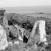
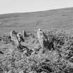
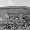
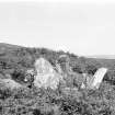
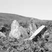
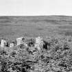
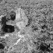
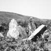
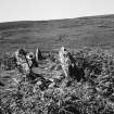
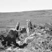
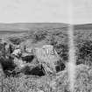
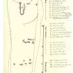
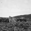
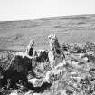
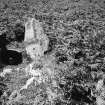
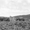
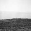
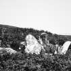
This cairn, the largest and most elaborate in Kintyre (Pl. 8B), is situated a little over 1.2 km NW. of Kilkeddan farmhouse on a fairly level shelf on the S. slopes of Maol a' Chuir, overlooking the N. side of Glen Lussa from a height of 15O m O.D. Trapezoidal on plan (Fig. 14) and measuring about 35 m in length, the cairn is orientated E. and W. with the broader and higher end to the E. Here it is 1.8 m high and 10.7 m broad, but the height dwindles to 0·6 m at the rounded W. end which is about 9 m broad. Near the W. end of the S. side the debris and turf have been cleared away to reveal a 4.3 m stretch of the lowest course of a revetment wall which presumably continues right round the perimeter of the cairn. At the E. end a well-defined concave forecourt, measuring 9.1 m across and at least 3.4 m in depth, gives access to the main burial chamber which is aligned E. and W. The forecourt is bounded by a façade of uprights, the largest of which stands 1.3 m in height. At the present time there are six orthostats visible in situ, including the N. portal stone of the chamber, and others are lying displaced within the forecourt area. In spite of the disturbance caused, it is quite probable that at least the lowest level of the original forecourt-blocking still remains intact.
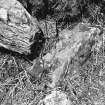
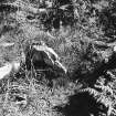
The main chamber (A) measures at least 3.8 m in length by 1.4 m in greatest breadth internally, and is divided into two roughly equal compartments by a transverse slab. Only the S. portal-stone and the roofing slabs are missing, but some of the surviving stones have been dislodged by the removal of the roof, and the interior of the chamber is choked with debris.
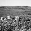
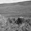
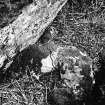
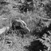
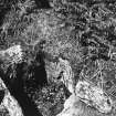
In addition to the main chamber there are four roofless side-chambers visible in the body of the cairn, all of them orientated N. and S. The first of these (B)lies about midway along the S. side; it measures 2.9 m by 0.8 m internally with the entrance facing S. It still retains its two portal-stones, the terminal slab and four of the side slabs; the entrance must originally have been flush with the edge of the cairn as the portal stones are in the same alignment as the stretch of revetment walling already mentioned.
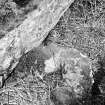
Two further side-chambers (C and D) lie 6 m to the W. They have been very badly damaged, but the seven stones that are visible suggest that the chambers were set back to back and were entered from opposite sides of the cairn. Neither of the terminal slabs can be seen, but chamber C probably measures at least 3 m in length and 0·8 m in width internally, while chamber D is slightly longer.
Situated 5 m further to the W., there is a fourth side chamber (E), opening to the N. The four surviving slabs establish that it is at least 2.4 m long and 0.5 m wide internally.
It is recorded (OS Name Book No. 75, p.15) that a large quantity of human bones was found in this cairn; mention is also made of "a large wadge of gold" which was recovered either from it or from the adjacent cairn (RCAHMS 1971 No. 32). None of these relics now survives.
RCAHMS 1971, visited May 1960
745268 cclii
Laser Scanning (5 March 2015 - 6 March 2015)
NR 745 268 (NR72NW 3) A laser scan survey of the horned long cairn of Gort na H-ulaidhe, was undertaken, 5–6 March 2015, for conservation management purposes. The survey was undertaken using a Trimble FX laser scanner, the survey was controlled using spherical targets, located using a Trimble S6 total station working on a local grid. Interpreted detail was surveyed in the field using the Trimble S6 total station, on the same grid as the control survey, allowing interpretation to be overlain on the laser scan data.
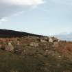
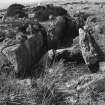
The façade, at the E end of the cairn comprises a crescentic arrangement of orthostats 10m N/S by 5m E/W, six of which remain in situ; a seventh stone has fallen out of place on the S horn of the cairn. The main chamber is c6m long, composed of four large upright slabs; a septal stone separates the first and second slabs into two chamber compartments. A rubble hollow to the W of the chamber is probably the result of robbing or digging. The main chamber is encased in a roughly circular rubble mound, standing to over 2m in height. Several large slabs immediately to the W of the chamber may be displaced cap stones.
A second chamber is located 7m S of the main chamber, it is 4m in length and entered from the S side of the cairn. The orthostats stand to 1.1m in height. The cairn surrounding chamber 2 has been heavily robbed and little cairn material survives in situ; a curving bank on the N side of the cairn between chambers 2 and 3 is probably the result of quarrying the cairn body, although it is also possible that the level terrace created by this bank represents the remains of a later building.
Chamber 3 is also accessed from the S side of the cairn and comprises five upright orthostats. It is likely that the N end comprises a further small chamber entered from the N side of the cairn suggested by one fallen and one standing orthostat. Chamber 5 is comprised of two large threshold orthostats forming an entrance into a chamber 2.5m in length, accessed from the N. The E side is formed by one large slab 1.2m in length but the W side of the chamber is missing.
The edges of the cairn are relatively clear, though surrounded by rubble spread, and on the S side at the W end of the cairn a short length of low coursed walling, probably the original kerb is visible. Rubble mounds surround the cairn on the N and S sides, probably largely collapse or debris from stone robbing. However, a small mound 10m SE of the cairn contains some earthfast stones and may be a satellite feature. A small ruinous farmstead and enclosure (NR72NW 39) is located 100m to the W, and may account for much of the stone robbing of the cairn.
Archive: National Record of the Historic Environment (NRHE) intended
Funder: Forestry Commission Scotland
Graeme Cavers – AOC Archaeology Group
(Source: DES, Volume 16)

