
Jura, Lussagiven


Kiln(S) (Period Unassigned), Township (Period Unassigned)
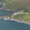
Site Name Jura, Lussagiven
Classification Kiln(S) (Period Unassigned), Township (Period Unassigned)
Canmore ID 38652
Site Number NR68NW 6
NGR NR 636 868
NGR Description Centred on NR 636 868
Datum OSGB36 - NGR
Permalink http://canmore.org.uk/site/38652


- Council Argyll And Bute
- Parish Jura
- Former Region Strathclyde
- Former District Argyll And Bute
- Former County Argyll
NR68NW 6 centred on 636 868
See NR68NW 9 for deatils of building
(NR 6347 8684 and NR6369 8665 ) Two corn-drying kilns: (i) situated just NW of the road, and (ii) immediately N of the SW house in Lussagiven.
J Mercer 1972
The former kiln is 3.6m in diameter with the central area relatively free of debris; the latter is 6.0m in diameter with its centre filled with debris.
Visited by OS 25 May 1978
Three unroofed buildings, two partially roofed buildings, one of which is a long building, twelve roofed buildings, six enclosures and a lime kiln are depicted on the OS 1st edition 6-inch map (Argyllshire 1881, sheet clxviii). The lime kiln lies in the same location as structure (i) identified by Mercer.
Four unroofed, two partially roofed, four roofed buildings and three enclosures are shown on the current edition of the OS 1:10000 map (1975).
Information from RCAHMS (SAH) 21 October 1998

