
Pricing Change
New pricing for orders of material from this site will come into place shortly. Charges for supply of digital images, digitisation on demand, prints and licensing will be altered.
Dun Domhnuill


Dun (Period Unassigned)
Site Name Dun Domhnuill
Classification Dun (Period Unassigned)
Alternative Name(s) Seafield
Canmore ID 38567
Site Number NR64SE 20
NGR NR 6815 4086
Datum OSGB36 - NGR
Permalink http://canmore.org.uk/site/38567


- Council Argyll And Bute
- Parish Killean And Kilchenzie
- Former Region Strathclyde
- Former District Argyll And Bute
- Former County Argyll
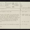
NR64SE 20 6815 4086.
(NR 6814 4085) Dun Domhnuill (Fort) (NR)
OS 6" map, (1924)
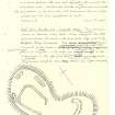
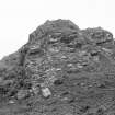
This dun occupies most of the summit of an isolated rock, 12m in height. Parts of the wall, including the entrance which was probably on the W, have been destroyed by the crumbling of the rock face. The remainder now appears as a band of core material, bordered on the N by a stretch of outer facing-stones. The interior of the dun measures 15m in length by 7.5m in maximum width; it contains the foundation of a rectangular structure which is very probably secondary.
RCAHMS 1971, visited 1960.
Dun Domhnuill (name verified) is as described and planned by the RCAHMS.
Surveyed at 1:2500.
Visited by OS 6 December 1977.
Field Visit (10 June 1943)
This site was included within the RCAHMS Emergency Survey (1942-3), an unpublished rescue project. Site descriptions, organised by county, vary from short notes to lengthy and full descriptions and are available to view online with contemporary sketches and photographs. The original typescripts, manuscripts, notebooks and photographs can also be consulted in the RCAHMS Search Room.
Information from RCAHMS (GFG) 10 December 2014.

