
Following the launch of trove.scot in February 2025 we are now planning the retiral of some of our webservices. Canmore will be switched off on 24th June 2025. Information about the closure can be found on the HES website: Retiral of HES web services | Historic Environment Scotland
Tangy Loch


Fortified House (Period Unassigned)
Site Name Tangy Loch
Classification Fortified House (Period Unassigned)
Canmore ID 38396
Site Number NR62NE 7
NGR NR 6956 2796
Datum OSGB36 - NGR
Permalink http://canmore.org.uk/site/38396


- Council Argyll And Bute
- Parish Killean And Kilchenzie
- Former Region Strathclyde
- Former District Argyll And Bute
- Former County Argyll
NR62NE 7 6956 2796.
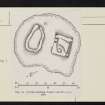
(NR 6956 2797) Fortified Dwelling. These remains occupy a small island situated towards the E end of Tangy Loch. The islet, which may be partially or wholly artificial in origin, is roughly D-shaped on plan, measures 21.6m from NE to SW by 18.3m transversely, and rises less than 2m above the surface of the loch. It appears to be composed almost entirely of small boulders, and traces of what seems to be an outer kerb or breakwater of similar material can be seen a little beyond the N and S shores. It is reported that under favourable conditions what appears to be a submerged causeway, paved with large stones, can be observed connecting the SW sector of the island with the SW shore of the loch (L Macinnes 1935) but this could not be located at the date of visit. The present depth of water over the causeway, which is said to vary from about 1.8m to 2.4m, would render such a causeway useless, but the level of the loch is thought to have been raised by about 1.2m towards the end of the 18th century in order to facilitate the operation of Tangy Mill. Moreover a local writer, in an article composed about the year 1838, reported that "in summer the island may be reached without a boat, but in winter it is inaccessible without some aid" (The Argyllshire Herald 17 July 1875) - a statement which suggests that a causeway may then have been in use.
Traces of two sub-rectangular stone buildings, now represented only by ruined turf-covered walls, occupy the central raised area of the island. The northern building is approximately square on plan and measures about 6.4m from NW to SE by about 5.5m transversely over all. The NE wall appears to have been repaired in dry-stone masonry within fairly recent times, and now stands to a maximum height of three or four courses. Its existing width of 0.6m is unlikely to represent the true wall-thickness of the building, for a trial trench cut through the SW wall at the date of visit revealed a thickness of some 0.9m. The original masonry seems to have been laid without the use of lime mortar. Nothing can be made of the internal arrangement of the building, but there are traces of what appears to be an entrance doorway towards the NW end of the SW wall. The circular depression within the S corner of the building is probably of recent origin and may have been a stance for shooting wildfowl.
The southern building is even more ruinous than its neighbour. It appears to have measured about 8.5m from NW to SE, by about 5.0m transversely over all. The corners are noticeably rounded.
This is presumably the "insula et fortalitium de Ellanlochnacanage" which formed the subject of a charter grant by John, Bishop of the Isles, to the Earl and Countess of Argyll in 1576. The site is indicated as a dwelling-place on the Pont-Gordon Map of the second quarter of the 17th century, when Tangy was held by the MacEachan family, at least one member of whom is said to have resided in a house on the island. This residence is probably the one referred to by M'Intosh, who mentions the former existence in Tangy Glen of a MacEachan house bearing the date 1670 (P MacIntosh 1861).
RCAHMS 1971, visited 1964
No change to the RCAHMS report.
Surveyed at 1:10 000.
Visited by OS (JM) 9 November 1977

