
Pricing Change
New pricing for orders of material from this site will come into place shortly. Charges for supply of digital images, digitisation on demand, prints and licensing will be altered.
Fair Isle


Quarry(S) (Period Unassigned), Wall(S) (Period Unassigned)
Site Name Fair Isle
Classification Quarry(S) (Period Unassigned), Wall(S) (Period Unassigned)
Alternative Name(s) Fair Isle, Site 180
Canmore ID 3798
Site Number HZ27SW 131
NGR HZ 2070 7158
Datum OSGB36 - NGR
Permalink http://canmore.org.uk/site/3798


- Council Shetland Islands
- Parish Dunrossness
- Former Region Shetland Islands Area
- Former District Shetland
- Former County Shetland
HZ27SW 131 2070 7158.
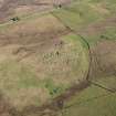
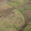
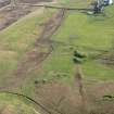
L-shaped delapidated walling c.5 x 2m with long axis orientated N-S. Maximum height c.0.7m and maximum width c.1m. Constructed using larger stones at base.
A number of small quarry-like workings in the vicinity, typically c.4 x 3m and c.0.5m deep, may be associated.
J R Hunter 1984.
Field Visit (1984)
L-shaped delapidated walling c.5 x 2m with long axis orientated N-S. Maximum height c.0.7m and maximum width c.1m. Constructed using larger stones at base.
A number of small quarry-like workings in the vicinity, typically c.4 x 3m and c.0.5m deep, may be associated.
J R Hunter 1984.

