
Following the launch of trove.scot in February 2025 we are now planning the retiral of some of our webservices. Canmore will be switched off on 24th June 2025. Information about the closure can be found on the HES website: Retiral of HES web services | Historic Environment Scotland
Colonsay, Dun Tealtaig


Fort (Later Prehistoric)
Site Name Colonsay, Dun Tealtaig
Classification Fort (Later Prehistoric)
Canmore ID 37835
Site Number NR39NE 2
NGR NR 38906 98397
Datum OSGB36 - NGR
Permalink http://canmore.org.uk/site/37835


- Council Argyll And Bute
- Parish Colonsay And Oronsay
- Former Region Strathclyde
- Former District Argyll And Bute
- Former County Argyll
NR39NE 2 3890 9839.
(NR 3872 9843) Dun Tealtaig (NR) (Site of)
OS 6" map (1900)
A strong promontory site with only natural defences and a few circular huts, with a narrow causeway to the mainland on the east. "Tealtaig" contains a Norse element meaning "hut" (information from Prof Watson).
S Piggott and C M Piggott 1948
NR 3890 9840: This promontory fort measures internally 46.0m NE-SW by 48.0m within a stone wall up to 1.0m high. The wall is best preserved in the S and SE where an outer face survives. Elsewhere steep cliffs provide adequate defence. The entrance is not apparent but could only have been on the S.
Within the interior on the N are four hut circles, levelled into the hillside and measuring from 4.3m to 8.5m in diameter.
Surveyed at 1:2500.
Visited by OS (DWR) 16 April 1974
Field Visit (April 1979)
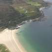
NR 389 983. This fort is situated 130m NE of Duntealtaig Cottage on a rocky promontory overlooking the W extremity of Kiloran Bay. The site is protected by sheer cliffs or steep rocky slopes on all sides except the SW, where access is easy.
The fort was defended by a single wall, which may originally have enclosed the whole of the promontory but which now survives only on the E and S, appearing as a low bank of rubble core material containing an unusually high proportion of earth, which was evidently an original element of its structure. A quarry has destroyed a section of the wall on the S. The position of the entrance is not clear, but it probably lay on the SW.
The interior falls steeply from a gently sloping terrace on the N and W, which provides the only reasonably level ground; and this area is now occupied by a number of small enclosures. Two of these (A and B on the RCAHMS plan) are U-shaped, share a common side and are formed by a low earth-and-stone bank; C is an oval scoop levelled into the terrace; and D is a rectangular area similarly levelled into the terrace and surrounded on the N, E and S by a low stony bank. Between B and C there is a level platform. The date and function of these enclosures are unknown, but A may be the foundations of a rectangular house, and B, C and D garden plots. Below the enclosures, and just behind the quarry, three shallow terraces may also have been cultivated.
RCAHMS 1984, visited April 1979
Measured Survey (1979)
RCAHMS surveyed the fort at Dùn Tealtaig using plane-table and alidade at a scale of 1:400. The resultant plan was redrawn in ink and published at a reduced scale (RCAHMS 1984, fig. 95).
Note (2 October 2014 - 15 August 2016)
The remains of a fort are visible on a promontory on the SW side of the mouth of Kiloran Bay. Irregular on plan and girt by cliffs everywhere except the neck on the SW, it measures about 40m from N to S by 38m transversely (0.12ha) within a wall reduced to a bank of earth and stones that can be traced around the southern and eastern margins. The entrance is not visible as such, but was probably on the SW. Within the interior there are traces of several small enclosures that RCAHMS investigators suggested were a small rectangular building and some garden plots.
Information from An Atlas of Hillforts of Great Britain and Ireland – 15 August 2016. Atlas of Hillforts SC2163

