
Pricing Change
New pricing for orders of material from this site will come into place shortly. Charges for supply of digital images, digitisation on demand, prints and licensing will be altered.
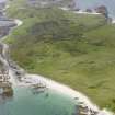
Oronsay, 'caisteal Nan Gillean 1'


Midden (Mesolithic)
Site Name Oronsay, 'caisteal Nan Gillean 1'
Classification Midden (Mesolithic)
Canmore ID 37820
Site Number NR38NE 8
NGR NR 3582 8797
Datum OSGB36 - NGR
Permalink http://canmore.org.uk/site/37820


- Council Argyll And Bute
- Parish Colonsay And Oronsay
- Former Region Strathclyde
- Former District Argyll And Bute
- Former County Argyll
NR38NE 8 3582 8897.
(Area: NR 359 879) Caisteal-nan-Gillean: "Fort of the Young Men" - A mesolithic midden which was almost removed during excavation by Grieve and Wm Galloway in 1881. The excavation produced a variety of implements of stone and bone, Obanian in type, as well as shells, bones of birds, fish and mammals, and hearths with patches of ashes and charcoal and fire-reddened stones. Before excavation it was an almost circular, cone-shaped mound overgrown with bent-grass, measuring about 150' in diameter. On the eastern side it was about 30' high and on the west 21 1/2'. It had been formed on the links sloping towards the sea, and gave the impression of being artificial. Galloway's collection from the excavation was donated to the National Museum of Antiquities of Scotland (NMAS). Their work is continuing in 1972.
A H Bishop 1913; S Grieve 1923; A D Lacaille 1954; P Mellars and S Payne 1971; P Mellars 1971
NR 3582 8797 - A large sandy mound mainly natural, which contains a vast quantity of shells. The excavation trenches have been backfilled.
Surveyed at 1:10000.
Visited by OS (DWR) 18 April 1974.
Desk Based Assessment (2 August 1972)
NR38NE 8 3582 8897.
Caisteal-nan-Gillean: "Fort of the Young Men" - A mesolithic midden which was almost removed during excavation by Grieve and Wm Galloway in 1881.
The excavation produced a variety of implements of stone and bone, Obanian in type, as well as shells, bones of birds, fish and mammals, and hearths with patches of ashes and charcoal and fire-reddened stones.
Before excavation it was an almost circular, cone-shaped mound overgrown with bent-grass, measuring about 150' in diameter. On the eastern side it was about 30' high and on the west 21 1/2'. It had been formed on the links sloping towards the sea, and gave the impression of being artificial.
Galloway's collection from the excavation was donated to the National Museum of Antiquities of Scotland (NMAS).
Their work is continuing in 1972.
Information from OS (ES) 2 August 1972
Sources: A H Bishop 1913; S Grieve 1923; A D Lacaille 1954; P Mellars and S Payne 1971; P Mellars 1971
Field Visit (18 April 1974)
NR 3582 8797 - A large sandy mound mainly natural, which contains a vast quantity of shells. The excavation trenches have been backfilled.
Surveyed at 1:10000.
Visited by OS (DWR) 18 April 1974.
Photo on OS 495 card.
Note (January 2017)
Mesolithic Scotland
The next stage of our journey through time takes us to a small island off the west coast of Scotland. The island of Oronsay sits directly to the south of its bigger brother Colonsay. Both are part of the island group known as the Inner Hebrides. Although Oronsay is relatively small, only 5km2 in size, it is rich in archaeology. In fact, Oronsay is home to the highest identified concentration of Mesolithic sites in Scotland dating to sometime between 7000 and 5000 years ago.
The Stone Age is split into three recognised phases: the ‘Palaeolithic’ meaning the old stone age, the ‘Mesolithic’ meaning the middle stone age and the ‘Neolithic’ meaning the new stone age. Much like the Palaeolithic age, there are very few known archaeological sites in Scotland that have been dated to the Mesolithic. Those that have been identified suggest that the communities moved around and survived by gathering food and hunting, likely using water as the primary method of transport.
One of the main site types that have been identified are known as ‘middens’. These are large mounds made of huge quantities of sea shells and other waste material. There are at least five known middens on Oronsay which include shells such as limpets, periwinkles, whelks, oysters, cockles, scallops and razorshells as well as a variety of fish. They have been found to contain very few remains from mammals that live on land or from birds.
Food and function
The primary type of fish identified in the Oronsay middens is from a species known as Saithe – a type of Pollock. This fish grows rapidly during the first 2-3 years of life. By examining the size of Saithe earbones recovered from the middens, archaeologists have been able to establish during which season the fish were caught at each site. Interestingly, the five middens examined across the island appear to have been occupied at different times of year. Archaeologists think that either there was one population of people living on the island who moved from place to place throughout the year, or that foragers from the mainland travelled across to Oronsay and camped at specific places in different seasons.
Middens are thought to have mainly functioned as rubbish dumps, created over numerous generations through fishing or shell-gathering expeditions. However, some archaeologists have suggested that middens have other, or even multiple, purposes. Could they have been created as boundary markers between different territories? Or perhaps, as occasional human toe or finger bones have appeared at midden sites, could these be places where bodies were prepared for burial or where mortuary rituals were practiced that we do not understand today?
Maya Hoole - Archaeology InSites project manager

