
Pricing Change
New pricing for orders of material from this site will come into place shortly. Charges for supply of digital images, digitisation on demand, prints and licensing will be altered.
Oronsay, Dun Domhnuill


Fort (Later Prehistoric)
Site Name Oronsay, Dun Domhnuill
Classification Fort (Later Prehistoric)
Alternative Name(s) Oronsay House
Canmore ID 37809
Site Number NR38NE 2
NGR NR 35426 89027
Datum OSGB36 - NGR
Permalink http://canmore.org.uk/site/37809


- Council Argyll And Bute
- Parish Colonsay And Oronsay
- Former Region Strathclyde
- Former District Argyll And Bute
- Former County Argyll
NR38NE 2 3541 8902.
(NR 3542 8901) Dun Domhnuill (NR) (Site of)
OS 6" map (1900)
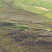
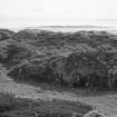
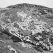
Dun Domhnuill, the robbed and overgrown remains of a contour fort about 200' by 80', on a site naturally defended by steep drops on all sides except the north where there is an additional stone line of defence. No definite entrance was traced, but there are vestiges of circular huts inside, especially on the west, and the remains of a midden. This site is comparable with Dun Cholla (NR39SE 12).
S Piggott and C M Piggott 1948
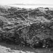
NR 3541 8902: A fort measuring internally 67.0m E-W by 23.5m within a stone wall best preserved on the NE where it is up to 3.0m wide and six outer courses high. No walling has been necessary on the S and SW sides. The entrance is not apparent but probably lay on the SE. Within the interior is a hut circle, abutting the fort wall and measuring 3.7m in diameter. Two circular hollows nearby possibly represent others. The midden occupies a large area on the S side of the fort.
Below the fort wall, on the E and most accessible side, is a substantial outwork wall with a single large outer face and rubble core up to 1.0m high. Access to this area is gained via a gully on the N with a paved pathway. A lower rock level to the E has been enclosed by a single line of vertical slabs.
Surveyed at 1/10 000.
Visited by OS (DWR) 18 April 1974
Field Visit (June 1976)
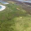
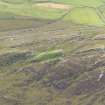
NR 354 890. This fort is situated 450m ENE of Oronsay House on the top of a rocky ridge which forms part of the E flank of Beinn Oronsay. On the N and E it is separated from the rest of the hill by steep-sided gullies and on the s it is protected by precipitous crags up to 30m high.
The fort measures 69m from E to W by 74m transversely over a wall up to 3.5m in thickness. No trace of the wall survives on the SW, and elsewhere it has been reduced to a low mound with a few stretches of the outer face still in position. Much of the w half of the interior is composed of bare rock, but the E half of the interior is level and grass covered. On the NNE there are the foundations of two oval huts which have been built over the collapsed fort wall (see also Dun Eibhinn and Dun Meadhonach on Colonsay), and to the W of them a basin (b on RCAHMS plan) measuring 0.6m by 0.5m and 0.3m in depth has been carved in a rock outcrop. A modern cairn (a on RCAHMS plan) stands at the W end of the interior. The entrance, which presumably lay on the E, was protected by an outwork enclosing a terrace some 3.5m below the fort wall. From the terrace a stone-revetted trackway leads down to the gully N of the fort. On a lower terrace, E of the outwork, there are traces of a recent enclosure comprising a turf wall on the N and several boulders on the E. A number of potsherds and a bone bobbin from the fort are preserved in the Hunterian Museum,
University of Glasgow.
RCAHMS 1984, visited June 1976
Measured Survey (1976)
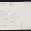
RCAHMS surveyed the fort at Dun Domhnuill using plane-table and alidade at a scale of 1:400. The resultant plan was redrawn in ink and published at a reduced scale (RCAHMS 1984, fig. 89B).
Note (1 October 2014 - 23 May 2016)
This fort occupies an elongated rocky ridge and is defended by a single wall that can be traced around the greater part of the margin of the summit to enclose an area measuring 69m from E to W by 24m transversely (0.12ha); runs of external face are visible on the NE and NW. The entrance is not visible, but was probably at the E end, where there are traces of a wall enclosing a lower terrace and a stone revetted trackway descends the slope towards the NW. On the N side of the interior the stone footings of two oval huts can be seen overlying the collapsed wall, and immediately to the W of them a stone basin has been cut into the outcrops; it measures 600mm by 500mm and 300mm deep.
Information from An Atlas of Hillforts of Great Britain and Ireland – 23 May 2016. Atlas of Hillforts SC2160

