
Tomnas Allan


Head Dyke (Post Medieval), Township (Post Medieval)
Site Name Tomnas Allan
Classification Head Dyke (Post Medieval), Township (Post Medieval)
Alternative Name(s) Allt Nan Cuinneag
Canmore ID 377560
Site Number NN76NE 34
NGR NN 7829 6795
Datum OSGB36 - NGR
Permalink http://canmore.org.uk/site/377560


- Council Perth And Kinross
- Parish Blair Atholl
- Former Region Tayside
- Former District Perth And Kinross
- Former County Perthshire
NN76NE 4 centred on 7801 6816
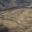
An extensive unnamed settlement abandoned and ruinous by 1860.
OS 6" map (1867)
A depopulated settlement comprising 30 buildings and several enclosures. The walls range from grass-covered footings c.0.2m high to drystone walls 1m high. The buildings range from c.7.0 by 3.0m to c.20.0 by 3.5m.
Visited by OS 5 October 1967
Fifteen unroofed buildings, several of which are annotated as Ruins and two of which are long buildings, three enclosures, a sheepfold, a field and a head-dyke are depicted on the 1st edition of the OS 6-inch map (Perthshire 1867, sheet xx). The head-dyke is shared to the S with two townships (NN76NE 7 and NN76NE 3 ).
Twenty-one unroofed buildings, five enclosures, a field and a head-dyke are shown on the current edition of the OS 1:10000 map (1986).
Information from RCAHMS (SAH) 25 September 1997
Field Visit (8 June 2015 - 17 June 2016)
NN 78474 67281 – Clunes – Post-medieval settlement (Canmore ID: 25148/SMR: MPK608)
NN 78297 67976 – Tomnasallan – Post-medieval township (Canmore ID: 25145/SMR: MPK605)
NN 77643 68328 – Craig – Post-medieval township (Canmore ID: 25145/SMR: MPK605)
NN 7775 6762 – Bruochriach – Post-medieval township (Canmore ID: 25144/SMR MPK604)
A walkover survey and desk-based assessment is being carried out along the route of the military road network in Highland Perthshire. The project aims to identify and record all sites and features associated with the road network, and its nearby/associated settlements, with a particular focus
on the 18th century. Two seasons of study have so far been completed, 8 June 2015 – 17 June 2016. Four settlements have been identified on the N and S sides of General Wade’s Military Road between Calvine and Dalnamein.
The settlement of Clunes contains a series of enclosures and 11 buildings, occupied into the mid-19th century. The military road initially ran through the middle of the settlement, before being diverted S of the settlement sometime in the mid- to late 18th century. A large enclosure now blocks the route of the original military road.
A head dyke runs NW from Clunes to the township of Tomnasallan, which consists of 14 pre-improvement and improvement period buildings, including a courtyard farmstead. To the W of the Allt nan Cuineag Burn, the head dyke continues W from Tomnasallan to the township of Craig, which consists of 18 pre-improvement period buildings, including a kiln barn, and enclosures. Some of the enclosures surround significant geological outcrops. There are also the remains of two possible hut circles within the vicinity of the settlement, and two very large enclosed mounds.
The head dyke runs SE from Craig to a further township, Bruochriach, which consists of four pre-improvement period buildings. The southern part of the original settlement may have been destroyed by the construction of the A9. The head dyke then continues E until it meets the Allt nan Cuineag Burn. Work will continue in the area in 2017.
Archive and report: HES (intended)
Funder: Heritage and Archaeological Research Practice Ltd
Website: www.harparchaeology.co.uk
Ian Hill and Michelle Gamble – Heritage and Archaeological Research Practice Ltd (HARP)
(Source: DES, Volume 17)
Note (1 February 2024)
NN 7764 6832
The abandoned settlement described by the OS are the remains of two townships recorded on James Scobie's 1783 map of Perthshire as 'Craig' (NN76NE 4) and 'Tomnas allan' (NN76NE 34).
Information from HES (L McCafferty) 1 February 2024

