
Oronsay, Druim Mor


Cairnfield (Period Unassigned)
Site Name Oronsay, Druim Mor
Classification Cairnfield (Period Unassigned)
Alternative Name(s) Rubha Caol
Canmore ID 377210
Site Number NR38NE 13.03
NGR NR 3573 8755
Datum OSGB36 - NGR
Permalink http://canmore.org.uk/site/377210


- Council Argyll And Bute
- Parish Colonsay And Oronsay
- Former Region Strathclyde
- Former District Argyll And Bute
- Former County Argyll
Measured Survey (1978)
RCAHMS surveyed the hut-circle, field-system and cairns at Druim Mor at a scale of 1:1000. The plans, covering some 55 hectares, were redrawn in ink and published at a reduced scale (RCAHMS 1984, opp p.136).
Field Visit (April 1979)
Formerly recorded under Canmore ID 37802
See also Canmore ID 377195, 377205-377210
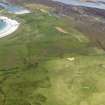
Situated on Druim Mor, the broad peninsula that forms the SW limb of Oronsay, there are the extensive remains of a
multiperiod field-system, several groups of cairns and a hut-circle. The various elements are described as they occur from SW to NE (see plan RCAHMS 1984, opp 136).
(6) To the E of (5) there are a number of cairns scattered over a wide area extending to the E of a nineteenth-century
wall which cuts off the sw end of Druim Mor. They range from 2m to 4m in diameter and measure up to 0.7m in
height. At least one recent clearance-heap is visible amongst the cairns.
RCAHMS 1984, visited April 1979.

