 |
On-line Digital Images |
DP 018803 |
|
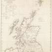
Engraving of map inscr: ''Map of Scotland shewing The Highland Roads and Bridges made, the Harbours improved and Churches built in the Highlands, also the Glasgow and Lanarkshire Roads, all according to the Plans of Thomas Telford. Shewing also the Old Military Roads still maintained in use.'' |
c. 1838 |
Item Level |
|
 |
On-line Digital Images |
SC 1683196 |
RCAHMS Aerial Photography |
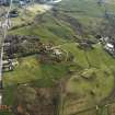
Oblique aerial view centred on the burial-ground, church and manse with the house adjacent, taken from the WSW.
|
12/5/2005 |
Item Level |
|
 |
On-line Digital Images |
SC 1683197 |
RCAHMS Aerial Photography |
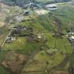
Oblique aerial view centred on the burial-ground, church and manse with the house and village adjacent, taken from the SW.
|
12/5/2005 |
Item Level |
|
 |
On-line Digital Images |
SC 2414267 |
Records of the Ordnance Survey, Southampton, Hampshire, England |
Islay, Ballygrant, The Old Manse, NR36NE 31, Ordnance Survey index card, Recto |
1958 |
Item Level |
|
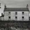 |
On-line Digital Images |
SC 2524118 |
Records of the Royal Commission on the Ancient and Historical Monuments of Scotland (RCAHMS), Edinbu |
Kilmeny Old Manse, Islay.
View from North West. |
1976 |
Item Level |
|
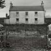 |
On-line Digital Images |
SC 2524119 |
Records of the Royal Commission on the Ancient and Historical Monuments of Scotland (RCAHMS), Edinbu |
Kilmeny Old Manse, Islay.
View from North West from beyond gates. |
1976 |
Item Level |
|


