
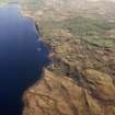
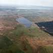
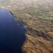
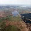
Islay, Loch Finlaggan, Eilean Mhuireill


Building(S) (Medieval), Crannog (Period Unknown)(Possible), Island Dwelling (Medieval), Quern (Period Unknown)
Site Name Islay, Loch Finlaggan, Eilean Mhuireill
Classification Building(S) (Medieval), Crannog (Period Unknown)(Possible), Island Dwelling (Medieval), Quern (Period Unknown)
Canmore ID 37694
Site Number NR36NE 23
NGR NR 38677 67339
Datum OSGB36 - NGR
Permalink http://canmore.org.uk/site/37694


- Council Argyll And Bute
- Parish Killarow And Kilmeny
- Former Region Strathclyde
- Former District Argyll And Bute
- Former County Argyll
NR36NE 23 3867 6733
(NR 3867 6733). Eilean Mhuireill appears to have been artificially made: it is said to be the site of an ancient building, uses as a prison by the Lords of the Isles (Macdonalds).
Name Book 1878.
When viewed from a nearby boat, Eilean Mhuireill gave the impression of having been built or reconstructed with large boulders. No causeway was apparent. At its N end are traces of a rectangular building, some 24ft by 13ft, with traces of an adjacent building of uncertain plan. (Local tradition of use as a prison by the Macdonalds is also given).
F Celoria 1959.
Eilean Mhuireill is a crannog, overgrown with scrub, and measuring 22.0m by 18.0m and 1.2m high. Traces of a boulder revettment occur around the base. There is no indication of any causeway; the water channel between the island and the near shore is fairly deep. The buildings on the island are as described.
Surveyed at 1:10 000.
Visited by OS (JM). 8 June 1978.
NR 3867 6733 Located 51m from the SE shore of Loch Finlaggan. At the time of survey, the depth of the water immediately surrounding the site was between 1.5-2m, with water 3m+ in depth immediately to the N and E of the islet. Eilean Mhuireill is an oval mound of stone which measures 30m NW-SE by 51m NE-SW at its base, with its long axis running parallel with the S shore of Loch Finlaggan. The surface of the islet is covered with a mixture of 80% medium-sized stone and 20% large boulders. The upper platform which stands 2.5m above the surrounding loch bed is also oval, measuring 17.5m NE-SW by 12.5m NW-SE. The turf-covered remains of a substantial perimeter wall could be traced around the margin of the upper platform. It was not possible to make an accurate measurement of the width of the wall due to the density of the undergrowth. At the time of survey, the surface of the islet was covered with a dense growth of briars and thorns and a small tree had taken root on the S side of the site. No trace of a causeway was found connecting the site to shore.
The remains of one of the sub-rectangular buildings (building a) previously noted by the RCAHMS were still visible through the undergrowth, however the other structure (building b) was completely obscured by briars and turf. The remains of what the RCAHMS described as a boat noost were observed in the NW sector of the site. This feature is a slight depression in the islet?s surface and is most pronounced at the water line but continues down to the bottom of the islet?s stone covering. The depression is 2.7m in average width but only 0.4m in average depth.
Sponsors: Edinburgh University Archaeology Department, Holley & Associates.
MW Holley 1996.
Field Visit (May 1976)
NR 386 673. This small island, which appears to be largely artificial in origin, is situated about 35m from the E shore of Loch Finlaggan and over 0.7 km S of Eilean Mor (RCAHMS 1984, No. 404). It is subcircular on plan measuring about 23m on its longer NE-SW axis by 19m transversely above the water-level at the date of visit. An inlet in the NW shore marks the position of a boat-landing and jetty, and in the SW sector the stony margin of the island includes a boulder footings-course of a perimeter-wall visible over a length of about 5m. The summit of the island, which is about 1m above water-level, is occupied by the ruins of two substantial drystone buildings of oblong plan, one of which (A on RCAHMS 1984 plan) is aligned NE-SW and is separated by a narrow passage from the transversely-aligned building B (on RCAHMS plan).
Building A measures 7m axially by 3m in width within round-angled rubble walls which are slightly more than I m in both average thickness and height. There is a straight-sided doorway 0.7m wide placed near the centre of the NW side-wall, and there are slight traces of an opening in a corresponding position in the opposite wall. The SW portion of the interior is subdivided by a low stone kerb which appears to stop about 0.4m short of the SE side-wall.
The slightly larger building B measures 7.8m in internal length by 3.5m transversely. The walls are of a similar construction and thickness commensurate with those of A except along the SW side where they are reduced to a width of about 0.5m. The entrance, which is placed towards the SE end of this wall, adjacent to the passage between the two buildings, is about 0.5m in width internally and has outward splayed reveals.
Among the rubble debris on the island is a roughly-dressed flat slab, which incorporates a small circular aperture and appears to represent a fragment of a quern-stone.
The site has no recorded history, and the name of the island is of uncertain etymology. On typological grounds the construction and occupation of the buildings can probably be ascribed to a period between the 14th and the 17th centuries.
RCAHMS 1984, visited May 1976.
Measured Survey (1976)
RCAHMS surveyed the island-dwelling at Eilean Mhuireil at a scale of 1:200. The plan was redrawn in ink and published at a reduced scale (RCAHMS 1984, fig. 154B).

